Glorious … Grand Canyon

The Colorado River is life. For millions of years its 2,000 km flow from the Rocky Mountains to the Gulf of Mexico has refreshed and powered seven US states. The cool fresh water quenches 25 million people and irrigates 3.5 million acres of farmland. On the Colorado Plateau, the relentless flow has slowly worn away the hard granite rock to carve a channel deep in the Earth’s crust. The river leaves in its wake one of the most stunning Natural Wonders of the World … the Grand Canyon.

Today I am to visit the Grand Canyon, but I feel unsure … what will I see? How will I feel?

I’ve made a classic mistake of course – thinking  “it’s not far from Las Vegas … so it won’t take long to get there, right?”

Well … wrong …

At its closest point (the West Rim) the Grand Canyon is 200 km from Las Vegas. But that’s not even where I’m headed. Today I am to visit the South Rim … and that’s a whole other prospect … I learn it’s 450 km away.

One good thing about my journey to the South Rim is that at least there are interesting things along the way. I pass Hoover Dam and Boulder City then get to Kingman. From here, I take a section of Route 66 to Williams – the last town to be bypassed when Route 66 was superseded by Highway 40 in 1984. Now, although it hosts the terminus of the Grand Canyon Railway for visitors to Grand Canyon Village, Williams relies heavily on its Route 66 history and cult following for tourism. Its main street boasts a range of fifties and sixties style stores with memorabilia and some ‘wild west’ history too.

IMG_4486

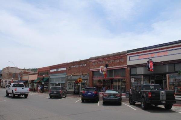
Route 66 – runs through Williams’ as the Main Street


I find a very nice sandwich here at Cafe 326, then head north from Williams and expect the mighty Grand Canyon to appear before me at any minute … at every bend in the road I brace, ready to see its vastness.  That’s another misnomer – although it’s 16 km wide and could hold 4 million Empire State Buildings, the Grand Canyon is deep – not high – so it can’t actually be seen from a distance. This is a difficult one for my brain to comprehend.

Wait … what? …. a 6,500 square km crevice carved into the Earth – could actually be passed by without me knowing it? …..

IMG_4531

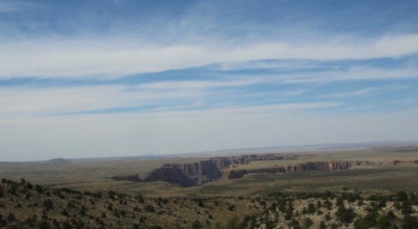
The giant crevice in the Earth’s crust – seen from about 20km away

The road goes on …. and on … and on …


Come on!  …. am I even going to get there today?

At last I arrive at Grand Canyon Village … I’m here!!
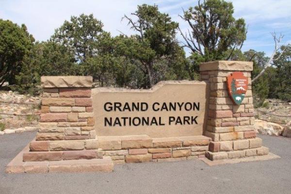
IMG_4523

I’m here!


I drive into the South Rim car park. I see trails, but I don’t yet see any Canyon … where is it? which way?

From the car park I follow signs along a short walking track. There’s a few people around, but it’s not noisy … I can feel, I can hear … I know it’s coming. The trail snakes around a bend … then I see something … ahead I can make out distinctive red layers and haze … the trail broadens out to a platform … yes … I’m here.

IMG_4508

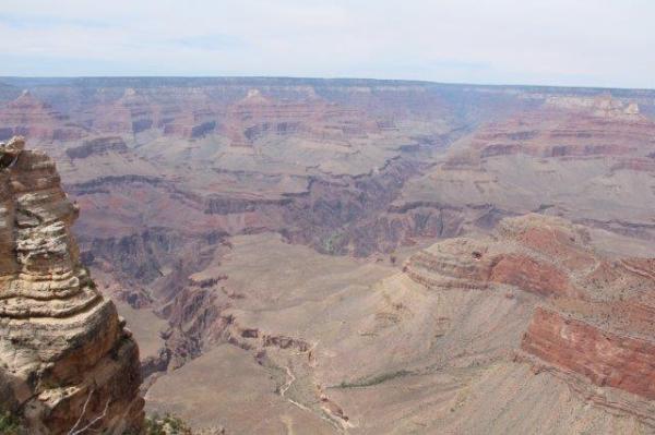
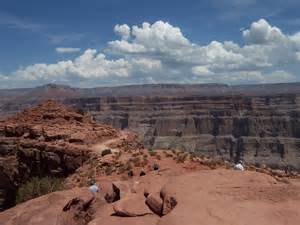
Grand Canyon – view from the South Rim


I take a few tentative steps forward and wait for the feeling to hit me … my eyes can see it – but … my senses are numb.

What am I looking at?

What is this in front of me?

How do I make sense of what I see?

I’m standing at the rim of the Grand Canyon. A fence stops me going further forward … I grasp the handrail and I just look. The sight and sheer size greets me – but I stop – I don’t know what I’m seeing … I feel nothing.

The people around me dissolve into my sub-conscious … I stand quietly and let the view soak through my brain. I can’t process it.

I stop and let it happen …

I slowly start to move – I step back from the view and go left a few metres along the trail … I stop again, I look, I take it in …. then I walk back the other way …

My guide is correct … it doesn’t matter where you find your vantage point, it’s so big everyone gets their own place to experience it.

This is mine … I stand and let it happen.

I can’t see down as far as the river, but I can see the deepness of the gorge – it’s almost 2 km down to the water.

My brother’s words come to me ….

“It’s not the fall that hurts – it’s the sudden stop at the bottom …”

The height and the drop don’t frighten me – in fact, I feel a sense of peace and calmness.

My senses start to awaken … now I feel it … my eyes start to appreciate the beauty.
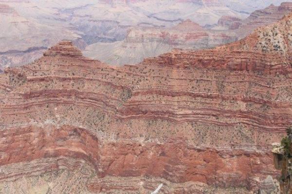
IMG_4512

The russet layers


The russet colour of the rock is the first to strike me – the even layers snake their way around the cliffs, each giving a natural “tide mark” to the canyon walls and a pointer to the passage of time. The colourful strata were set down during the creation of the plateau, then exposed again as the river gradually eroded its way through the granite on its journey to Mexico.

From where I stand, it’s ten … yes, TEN… miles across to the other side. It’s these numbers that give me so much trouble in appreciating what I see. Apart from the people – all on the side I am on – there’s no point of reference. There’s certainly nothing possible to compare and gain a perspective. My eyes pore over the surface of the rocks – the colours and patterns are only something nature could make. Thousands of hues of rusty red, beige and black. A painter would enjoy emulating these colours in their work … the variations tease my eyes and make my heart sing … I am confident that the overused word “awesome” is right to use here.

After a while, I drive around to the Desert View observation point. Here, at least I can see down to the Colorado River.

Aah, that’s better – now I can at least get a better sense of it.

IMG_4526

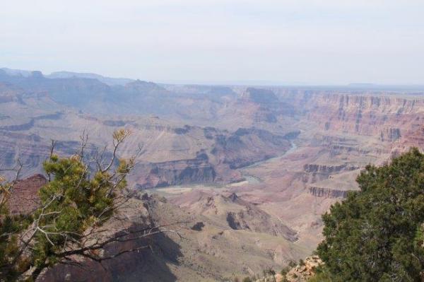
Grand Canyon, Desert View

From here, the green Colorado River clearly works its way left to right, towards the Gulf of Mexico.  Yes, now I can get it straight. The wind blusters around me, it’s precarious … there is no guard rail here, so a visitor could just keep on walking if they wanted to (or even did it by mistake). It seems people don’t come here to do that though – 48 million people visit the Grand Canyon each year, but records show that as few as 12 people are lost through falls into the Canyon annually.

Well at least people keep their wits about them when they’re here, particularly on a blustery day like today.

This region is a sacred site for indigenous Native Americans, whose people have lived in natural caves and built settlements along the canyon floor since 1200 BC. Those who live a little further away take pilgrimages to visit this holy ground. The first people to live in the Grand Canyon were the Ancestral Puebloans, (also referred to as the Anasazi – Navajo for “Ancient Ones” or “Ancient Enemy”). Over the centuries, other cultures have inhabited the area – primarily Cohonina, the ancestors of the present day Yuman, Havasupai, Hualapai and Walapai people; Europeans arrived here in the 16th century.

IMG_4770

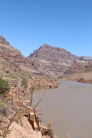
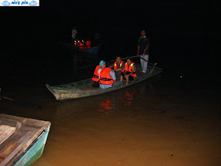
Jetty at Haluapai River Riders

The Hualapai people are still in the area and they live within their own “reservation” – land that’s been identified by the US Government for habitation by the Native Americans. It is partitioned off from the rest of the National Park. Within the “reservation”, Native Americans run their own businesses and live under their own laws, outside the jurisdiction of the US Government. The traditional Haluapai land is at the West Rim – which I reach by helicopter.

My pilot, Chuck, drops me off on the banks of the river. My first experience here is to take a river cruise along the mighty Colorado, so I make my way to the jetty. The Hualapai people provide a cruise for visitors along their portion of the river. These are the Hualapai River Runners – at first there’s a bracing ride at speed for 2km along the river, then it becomes a relaxing and spectacular return trip as we cruise back to the jetty – the sun blazes down, the river glides and the 4,000 ft granite peaks tower high above me.

After the cruise, I take a helicopter back up to the “rim” – to Grand Canyon West Airport. Here a shuttle bus transports visitors around the Hualapai Reservation which offers three places of interest.  The bus runs often and it’s possible to spend good time at each stop. First stop – Hualapai Ranch. The mood of this area is relaxed and fun, but informative. It’s operated by Native American staff who help visitors understand their culture, traditions and practices. A particular favourite amongst visitors is the “quick-draw” competition where two wanna-be cowboys see who’s fastest on the pistol draw. People get a sense of the “cowboy” heritage of this area … and non-PC visitors may recall their own childhood “Cowboys and Indians” pursuit games with some fondness.

IMG_4795

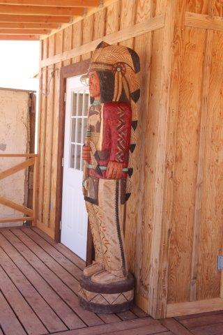
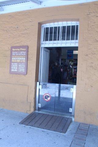
A guardian stands outside a Haluapai Ranch store

I enjoy the crafts on display here – colourful pottery and lovely turquoise and silver jewellery.  Native Americans recognised the wealth of the minerals in Nevada centuries ago. They used the copper and silver for arrowheads, spear points and tools.

This was the beginning of Nevada’s rich mining industry – particularly in silver, which was a key contributor to the state’s economy and  lead to Nevada being admitted to the United States in 1864. Of course, tourism and gaming dominate the economy today, but Nevada is still a significant national and international source of metals and minerals such as gold, copper, molybdenum (for steel), lithium, gypsum and lime.

This is what can cause the waters in the Colorado River to colour so brightly – depending on the day’s runoff from surrounding rocks – copper makes green water; iron makes red “rusty” water.

Next stop at Grand Canyon West Rim is Eagle Point – a popular stop for most of the visitors to Grand Canyon West. Here, the courageous can take their turn on the SkyWalk – a horseshoe-shaped bridge that features a glass walkway. Walkers can see down to the river, 1,450 metres (4,000 feet) below, as they walk.

Yes … it’s not for everyone.

IMG_4819

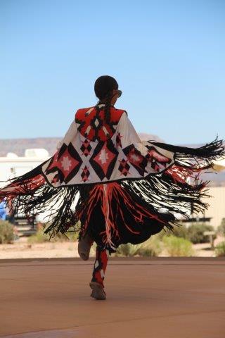
Spectacular traditional dance

My favourite feature at Eagle Point is the experience of Native American culture at the village. I enjoy the traditional dance and music. The costumes are brightly decorated, made of suede and leather with tassles, feathers and braids. As the dancers move the adornments fly out to create a colourful, moving space around them. The music is dominated by chanting and a regular tom-tom beat …

Heeeee … un, un, un

Heeeee …. un, un, un ….

it’s mesmerizing. They don’t invite me to join in … shame.

The tribal heritage is demonstrated through several types of village structures – they’re adobe, mud that’s been baked in the hot sun … so hot that eggs will cook in an outdoor pan without fire. The ingenuity of the huts intrigues me – the natural material keeps out the heat, but they’re constructed in a cone shape where an opening near the top facilitates movement of steam that’s important for prayer rituals – during prayer, steam is believed to cleanse the mind, body and spirit.

It’s fascinating – the tribes make the most of all their natural resources and the botanical  ingredients of their surroundings. One particularly catches my eye … the Hogan.
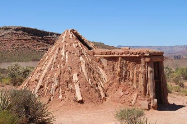
IMG_4852

Intriguing Hogan ….

A Hogan is traditionally built using wood and mud. The mud is important because it is a part of the Earth and the wood pieces are carefully selected – they can’t come from any tree struck by lightning, as objects struck by such a powerful force are said to have lost their spirit. The structure’s wooden beams create a funnel for light and the circular shape at the base symbolises the World. The entrance faces the East because everything that is good and prosperous comes with the dawn of a new day and an eastward facing entrance invites blessings into the home.

How wonderful … it’s so simple – yet everything has a deep spiritual positive meaning …

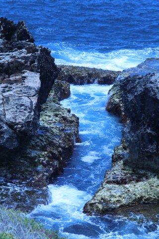
Most spectacular of all at West Rim is the final stop – Guano Point. Here, the red strata on the sheer canyon walls draws me closer to the view. The area is shaped like a pyramid and a walk to the tip rewards me with an almost 360-degree perspective of the Canyon – breathtaking.

Guano

Guano Point

In the early 20th century an aerial tramway crossed the Canyon here, to reach a cave filled with valuable guano (bat droppings) – high in phosphate and a critical ingredient for fertilizer. In 1957, the U.S. Guano Corporation estimated the cave held 100,000 tons of guano with a net worth of $12 to $15 million USD. But, of course, the cave was in a hard-to-reach spot. The first attempt at mining the guano involved building a tramway to connect the cave with a barge dock below.

But … although it was a good (albeit ambitious) plan, the risks gradually overtook the rewards – the company went bankrupt as a result of high expense for motor repairs and barges that were sunk during the operation. The tramway tracks still cross 3 km to the other side of the canyon – it’s impressive. Such engineering prowess back in the early days!

Actually … even today, that would be something to achieve.

IMG_4884

Lake Mead, from my helicopter


I make my way back to Chuck at the helicopter.  We take off and fly back to Las Vegas, over spectacular Lake Mead – a lake created during the flooding of the Colorado River for the Hoover Dam.

Once the two year construction of the dam was completed, the wonderful lake took seven years to fill. In water capacity, it’s the largest reservoir in the US, with over 1,200 km of shoreline. It provides water to Arizona, Nevada and California.

It’s also a beautiful water feature and popular area for leisure and water pursuits for visitors and locals.

Its blue waters and unique shoreline provide a spectacular backdrop to the flight back to Las Vegas. Although it provides water for over 20 million people and acres of farmland, the Lake suffers from factors that have diminished its reserves – natural drought and increased demand.  It has recently seen a drop in its levels. This is quite evident from the air, particularly where the banks only gently slope into the water – here the receding water line is bright and stark.

IMG_4887

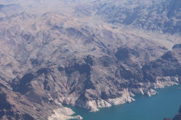
The lighter banks show the receding Lake Mead

It’s plain to see from this vantage point that the magnificent Lake is not what it once was. Boating is the most popular leisure activity on the Lake, with fishing, water skiing and swimming all attracting holidaymakers. It has four marinas and house-boats are dotted around its many coves that feature rocky cliffs and sandy beaches. Depending on the water level, several small islands can appear too.

Our flight continues over the Hoover Dam and back to McCarran International Airport in Las Vegas. This airport’s deceptive – because the famous Las Vegas Strip has such massive buildings, the airport – although a major international hub – is dwarfed into seeming more like a small city operation, which it is not … by a long way. 40 million visitors come to Las Vegas every year and most use this airport for their transfers into and out of the city.

All too soon, my 45 minute direct flight back to Las Vegas comes to an end. Chuck flies me over The Strip, to get a good view of the brightly lit human drawcards, giant replica’s of famous landmarks and remarkable hotel facades – all there to draw the excited crowds. Then we land at McCarran.

It’s over .. my visit to the Glorious Grand Canyon …. what a marvellous day.

Now … to survive Las Vegas itself – that’s a story for another day ….


A Swim with the Sharks

I guess it’s one of those things that not everyone wants to do … voluntarily go underwater and spend time within a metre of several living, breathing, person-eating sharks. I did it.

Amongst other adventures, the SeaLife Melbourne Aquarium offers Shark Dive Xtreme for those who have the urge. I book my ticket for the Shark Dive and the administration begins. There’s several medical checks to do, just to make sure all the safety aspects of the dive are assessed. These must be done at least two weeks before my adventure. It’s important – there’s a GP’s Medical Clearance and a special Dive Health Check, conducted by a dive specialist. They check general health and ensure I have no particular health issues that would risk my safety while I’m underwater. For example, any problems with air pressure – my lungs, breathing or ears – would be checked thoroughly to ensure there’s no danger to me. It seems a tedious chore, but it’s for my own good.

The day of the dive arrives. I reach the front entrance at Melbourne Aquarium and even though it’s only 9.30am it’s very busy – on a Sunday morning too. Shark Dives don’t operate every day, only Friday to Monday, so weekends coincide with families and visitors who like to come to see the rest of the Aquarium. Even with a pre-paid voucher, I still have to line up to be checked off the list and admitted – there’s more forms to complete too. But then …. the admin stops and the fun starts …

After a short wait for all “divers” to arrive, our Dive Guide introduces himself to our small group (of only five) and we’re lead to a lower level into the dive area. We get instructions to tell our friends and families to come down to the “Mermaid’s Lagoon” to watch our dive. We’re subterranean now – out of the lift we gather in a small, wet area with lots of equipment and the surface of two large tanks in view. Here, we sit on the side of a tank on a cold concrete wall while our Guide gives us a comprehensive safety briefing.

IMG_3981

One of our fellow tank inhabitants

Although I haven’t SCUBA dived before (haven’t even snorkelled, actually), there’s no need to be concerned, the briefing covers everything a novice diver needs to know about what to do, what not to do and the creatures we’ll see below the surface. Every so often there’s a splash of water behind us – the tank’s surface breaks and a fin momentarily appears then disappears … it’s one of our fellow tank inhabitants – it’s fascinating and disarming at the same time.

Our Guide gives more instructions … there’s specific hand gestures to learn. Nobody can speak or hear underwater, so it’s critical to be able to relay messages between divers. We learn …

  • ” – Let’s go this way ….”
  • “ – I’m okay! …”
  • ” – Look up there ….”
  • ” – I don’t feel well ….”
  • ” – We will (or I want to) return to the surface …. “
  • ” – I can’t breathe ….”

The slideshow seems interminable … but then … our Guide heads to the rack of wet suits. He visually sizes each of us up and hands me a thick, black, full length rubber suit. Off to the ladies loo to get changed … it’s a struggle to get into the wetsuit – I wear swimming togs underneath, but it’s not that – the wetsuit must be firm but not tight, so I can still breathe comfortably. I tug at the legs of the stretchy suit to heave it up and over me … once it’s on and zipped up it’s fine – but getting it there is an effort!

I return to the briefing area and pull on black diving gloves, a helmet, mask and a pair of special dive shoes – with rubber soles to stop feet from slipping. We’re all covered head to foot in rubber … next – a weight belt, then … the heavy SCUBA tanks. Their bulk is significant –my knees start to buckle under the extra 30kg just added to my frame – well I won’t be stealing this  gear … I can’t walk with it, far less run away!

Then … we move to the side of the tank – I notice a ladder going over the wall and into the water. We slip on or flippers and finally … one by one we get into the water.

IMG_3988

Another fabulous tank dweller

The climb down under the surface is backwards – onto a submerged platform, with the water about armpit deep. Weirdly, my gear and I become weightless – I’m suddenly buoyant and my knees float up to the surface. The water temperature’s a shock – cold, but not unbearable. It seeps into my wet suit. Our Guide’s told us “… if you feel cold, there’s only one thing you can do to warm yourself up inside the wet suit – aside from going back to dry land, that is …” …. Yuk.

We meet our two water-based Dive Instructors and we’re given extra weights to keep us grounded. We put our heads under water for the first time …

Adrenalin rushes through me  …..

… Aahh! …

… I can’t breathe …

… I forget what he told me …

… what do I do … ?

 … okay, settle down …

 … that’s it …

… slow … deep breaths ….

… just relax ….

… think about slow breathing …

“Don’t smile or your mouthpiece’ll pop out …!”

“Clench your teeth over the mouthpiece to stop it coming out…”

 …. breathe …. relax

… breathe ….

Okay, I’m getting it now …. relax ….

We put our heads out of the water – everyone ok?

Yep … good …

We review the hand gestures and practice several critical dive skills – I learn to …

  • clear my mask of water – hold your mask to your head between your eyes and blow through your nose, so the water escapes out the bottom of the mask.
  • clear my mouthpiece of water – blow suddenly and the water mixed with air will be forced out of the mouthpiece. OR – put your tongue over the air inlet from the tank, then press the air button. Make sure your tongue’s over the inlet, or you’ll get a lung full of high pressure air … uncomfortable to say the least.
  • “equalise” underwater – to make my ears “pop” when I notice the pressure – gently hold my nose and blow … gently only.

Right … we’re ready …

IMG_3985

We can clearly see through to the people on the viewing deck

We go below … the Instructors guide each of us to another platform. Here, the creatures gently glide past – seemingly oblivious to us. Do they even see us?   Some are massive – giant Stingrays with fin spans bigger than us. A huge and colourful Leopard Shark, a Grey Nurse Shark and several brightly coloured fish.

It’s surreal – but marvellous.

Underwater, the only sound is the air – moving into my lungs, then out my mouthpiece in bubbles streaming to the surface. Don’t smile – or your mouthpiece will fly out!!

I can clearly see through the water, it’s crystal clear – just like glass. Look – there’s some people looking in from the viewing deck! Look, I can seem my family!  

The audience waves and I happily wave back. Don’t wave too near the fish or make any sudden gestures – this could upset the creatures going by and they might do something unpredictable.

We head to the bottom where a photographer peers through the glass to take our photos. Time seems to go so slowly … the Instructors point to things for us to see – a Shark glides by, a Stingray “flies” overhead, it’s magnificent fins work up and down in slow motion … lovely colourful fish …

We swim around under the Instructors’ guidance …

Don’t kick your flippers too hard … it’ll kick up all the sand and sh*t on the bottom into the diver behind’s face …”

The world stands still for 45 minutes as we glide smoothly along and enjoy the peaceful, surreal world … we stop every now and then to see what the Instructors are pointing at.

I love it …. it’s so gentle, silent, peaceful and remarkable …. Sharks, Stingrays and fish pass by all the time – some only arm’s distance away.

I want to reach out and touch them! 

All too soon, we get the “thumbs up” and must head back to the surface … what, already?

IMG_3989

Time to get out comes too soon …

We are gently brought back to the platform. Actually, now I think about it … I’m pretty cold! The inside of my mouth is coated in a layer of sea salt …

I reluctantly climb out of the tank and head to the ladies again to reverse the “wet suit struggle” …

Please … please have warm water in the shower ….

I’m so cold now, I can hardly grip my wet suit to pull it off … aargh … come off you son of a ….

Finally, it releases its hold on my skin and I can peel it off … my reward – a fabulous hot shower.

IMG_3990

A totally marvellous experience!

Washed, dried, warm and fluffed up once again, I return the wetsuit and gear to the Guide and thank the Instructors incessantly for the experience. They were totally marvellous -careful, professional and fully aware of our safety at all times.

Time to go … let’s find the photos they took …..

A day on Rottnest Island … 

Rottnest-and-Perth

The Rottnest Express shuttle collects me from my Perth hotel at 8.10am and we reach Barrack Street Jetty in good time. I pick up the ticket I booked online yesterday ($99 for the round trip) and board the 8.30am ferry – it’s booked solid – everyone is asked to take a seat for safety but we’re advised there will be none spare. We cruise along the Swan River for an hour as far as Fremantle. It’s flat and picturesque, I enjoy the informative commentary from our Rottnest Express tour guide, who points out various spots along the way and gives a potted history of Perth and the river. I expect to stop at Fremantle’s busy ferry terminal to pick up more passengers, but we just sail on past and leave the waiting passengers looking expectantly after us.

During summer, several return ferry services cross to Rottnest Island daily – one from Perth city and two from Fremantle. I sail another 40 mins across the open sea, then arrive at the Island’s main port – Thomson Bay – named after Robert Thomson, who became a major landholder on Rottnest Island during the 1830s.

IMG_3724

A warm welcome to Rottnest …

All the ferries come in here, it’s the site of the main settlement. At the end of the jetty is a shady tree outside the Rottnest Visitors’ Centre, a good place to get my bearings and consider my day.

I immediately notice one of the most striking features of the island’s buildings – their unique golden colour. When the settlement was established by the British in 1829, the rendered buildings were painted bright white, just as they are in the Greek Islands and other similar places. But the sailors and ships’ Captains complained that the whitewashed buildings caused too much glare for them to see clearly to shore, so given this is such an important commercial maritime location, plans were quickly made to change this and use a colour other than white.

IMG_3725

Rottnest “rust” coloured buildings

Being conscious of their limited resources, the Islanders were reluctant to waste their stock-pile of whitewash, so they recycled.

They added their old rusty nails and metals to the white, thus creating the “Rottnest Rust” colour still seen on most Island buildings today. Only one or two buildings display the whitewash now, to give visitors a sense of the original colour and its starkness against the bright blue sky.

The settlement’s Chapel is a good example of a remaining whitewashed building. In the centre of the village, it offers a haven for locals and visitors, out of the sun and away from the babble of holiday-makers. I step inside this lovely building and feel an immediate sense of history and peace. The small, but sweet chapel has several stained glass windows and a calm timber interior. The timber altar is austere, but beautiful.

IMG_3728

Settlement Chapel

Rottnest Island has no source of fresh water. The early British settlers thought wells could be used to access the water below ground, but the salty subterranean environment produces brackish water that’s undrinkable, so their wells proved useless. Although the island has several lakes, most of these are salty and many dry up during the hotter months of the year. Having given up on the Island’s own water, the settlers tried to develop catchment channels to trap run-off from the little rain that falls. Another unsatisfactory attempt – this Island is a difficult place to live.

One positive thing did come from the salt-laden surrounds, Rottnest Island became the main source of salt for the entire Australian mainland. As the lakes dry up each year, a residue of salt is left behind. The Islanders collected this for their own use and to sell. The Salt Store on the main settlement’s foreshore still stands to mark these times. Salt collected from the dried lakes was stored here until it was distributed across Australia. Rottnest Island supplied most of the salt for Australia for many years. Today the water supply is mainly desalinated sea water. After the Chapel, the Salt Store is the only other whitewashed building on the island. Although it’s no longer used for salt, it can still be seen from out at sea, but on its own it’s more a landmark for sailors than a safety hazard.

IMG_3797

Salt Store

A unique feature is the island’s Quokka population. These fascinating marsupials are very few in number on the mainland and the island is their main habitat. On the mainland, they are largely wiped out as a result of predators, but here they have no predators so it supports their largest population (around 12,000). Although they prefer to live in the shadows of the trees around the settlement, they are not timid and will approach humans with curiosity and to scavenge for food. The absence of any predators means they haven’t learned to be cautious, but they can’t tolerate human food so even though they hang out at all the village cafes, they can’t be fed.

There’s many a picnicker whose slipped a “sweet Quokka” a human morsel, only to quickly notice the animal become totally ill!

IMG_3737

Curious Quokka

In late 1696, the island was given the name “Rotte nest” (“rat nest” in the Dutch language of that time) by Dutch captain Willem de Vlamingh. As he explored the island, he saw all the quokkas and thought they were giant rats. After a week here, he described the island as a “…a paradise on earth”.

I take a Discovery Tour by bus to circumnavigate the island. We gently pass Porpoise Bay, named even though there are no porpoises here. Little Salmon Bay and Salmon Bay – two iconic lovely beaches.

IMG_3769

Wadjemup Lighthouse

Then we turn inland and head for the island’s first beacon – Wadjemup Lighthouse.

From here a spectacular view around the island is possible, just as the lighthouse-keeper would have had during its operation..

We head for Fish Hook Bay at the western end of the island. This lovely bay overlooks the stunning Cape Vlamingh and across the wide sea. The water crashes onto the rocks all around this small spit. I take the well made boardwalk and can walk right to the tip of the island – it’s wonderful to stand and watch the booming foamy waves and take it all in. I’m now facing southwest and there’s very little between me and Africa, just the vast Indian Ocean.

Along the northwest coast line is the shipwreck of the City of York. This ship’s plight significantly changed the island’s infrastructure.

On a bleak night in 1899, the City of York approached the island. The weather was particularly bad with limited visibility. The light housekeeper sent up a flare, but as the vessel’s Captain couldn’t see the island or lighthouse, he misread the signal – thinking it was provided to pilot the ship safely past the notorious rocks and into the bay. But the City of York founded on the rocks. All 24 crew abandoned ship and safely boarded the lifeboats.

IMG_3788

Cape Vlamingh

Then the Captain turned his lifeboat back, nobody is sure why … perhaps to ensure his abandoned vessel wouldn’t be seized as salvage. In the lifeboat were 11 crew and the Captain – all were lost.

After this incident, the second lighthouse (Bathurst Lighthouse) was established at the northern end of the island.

Being ever conscious of their self-sufficiency, the island has established a wind turbine to produce much of its electricity. The significant investment of $2.5 million to construct the turbine was made in 2005 and it was expected to “pay its way” within 10 years. Now, eleven years later, the production of the turbine is being observed by officials closely to check whether the return on investment is there – it currently contributes 30% of the Island’s summer electricity supply and 90% of its off-season supply.

Back at the settlement, I seek out some lunch and a coffee. There are lots of options, depending on your appetite, time available and budget. some lovely restaurants and pubs are along the foreshore, but in the settlement the crowds gravitate towards the Bakery. This offers a good range of standard lunch fare. I find a sandwich here and get a great coffee from The Lane, opposite. There’s lovely outdoor seating everywhere around the settlement – but don’t feed the Quokkas!

After lunch, I wander about the island for the afternoon.

IMG_3793

Quokka “gate”

Several businesses operate here to support tourism on the island. Most are accommodations, cafes or other types of eateries, with one or two shops. Here in the “town” Quokka’s abound. In fact, most of the businesses have a curious feature at their entrance. A knee-high gate … a barrier to stop the curious marsupials getting inside the store. It’s much like a reverse cat door, where humans can get through, but animals can’t

220 workers are employed by the businesses that support the Island, but only 110 actually live here. The Rottnest Island School has 12 students, with one teacher who lives on the island. This is a prized role, with teachers who land the job here often staying their entire career. Many workers commute from the Mainland each day – first ferry in, last ferry out.

The island is served by an airfield, used for both commercial activities and tourism, and (believe it or not) a railway. No private cars are allowed on the island, so a common form of transport is a bicycle or on foot. Private ownership of land is prohibited and no domestic pets are allowed. In fact, the island is virtually a National Park.

Several “prisons for Aborigines” have been in operation here, also the Rottnest Boys Reformatory – opened on 16 May 1881. Its purpose was to house delinquent young boys, rather than send them to prison. As a place to support the boys’ development, it had a workshop, kitchen, two large dormitories, a school room and four small cells. After twenty years, it closed in 1901 and the remaining 14 inmates were transferred to an industrial school on the mainland. The buildings are now used as holiday accommodation as part of the Rottnest Lodge.

There is a small historic European Cemetery here too.

IMG_3762

Snorklers enjoy the clear turquoise sea

Many people come to enjoy the broad beaches that surround the island. These are popular, but not over crowded, there’s plenty of room for everyone. Around 5.00pm I head back to the jetty and catch my ferry back to Perth – full once again. Being worn out from a busy day, the journey seems a lot quicker than the outward one.

I arrive back in Perth at around 6:15 pm and as I wander back to my hotel, I ponder happily on my day. As I walk along the Swan River promenade I notice two dolphins in the river just swimming playfully along…. aaah, such a marvellous place to visit.

I wonder what tomorrow will bring?

Photo source: http://www.bing.com/images/search?q=Rottnest+Island+from+Perth&view=detailv2&&id=4ED2B59EF9F2A082CA72B887F15B47D27F2DEFD0&selectedIndex=165&ccid=7fi9Uwdx&simid=608006424784339651&thid=OIP.Medf8bd530771ea7562485caf6e3510beo0&ajaxhist=0


An underground world … Cu Chi Tunnels, Vietnam

It’s a sad reflection of my ignorance about history, but I’ve never actually heard of Cu Chi or the Cu Chi Tunnels. However, I have heard of the War (known by me as the “Vietnam War” in the 1960’s and 70’s, but known in Vietnam as the “American War”), I’ve also heard of the Viet Cong in the same context. My childhood was punctuated by the nightly television news stories from Vietnam about troops from Australia and New Zealand who were deployed into the conflict as allies of the United States. So at least I can build my knowledge from there …

I drive for about an hour northwest of Ho Chi Minh City (around 70km, 45 miles) to the rural district of Cu Chi.

The area is green and lush with most land used for farms and small villages. Clearly, the area is poor and ekes out a self-sufficient existence with farming and also, no doubt, tourism. The site known as “Cu Chi Tunnels” is a portion of a huge network of underground tunnels (over 200km in distance) that involves much of Vietnam and has been a significant component of Vietnamese military defence capability in recent history. As a generally poor, agricultural nation, when involved in conflict, Vietnam had very little monetary reserves and therefore only rudimentary means of defence so it had to use anything it had available. Hence, the establishment of the tunnel network – first used against the French in the 1940’s, then against the Americans in the “American War” of the 1960’s and 1970’s.

In the 1940’s, the Vietnamese created the tunnels so local villagers could hide underground, launch surprise attacks on the French in the night and quickly escape to the banks of the nearby Mekong River. They’d virtually “disappear” – leaving the French baffled as to their whereabouts and their means of escape. After the conflict with the French, the miles of tunnels were not needed and abandoned, but thanks to the thick soil of the area the tunnels remained intact, so when the “American War”  arose, the Vietnamese could activate the tunnels again to take advantage of the same strategies.

In both cases, the Vietnamese were “tiny and silent predators” who would use stealth, surprise and the veil of darkness as camouflage – then attack. These were not “big-bang” fighters, but multitudes of individuals who repeatedly fought for their lives then disappeared – seemingly without trace, only to appear again later with just as much surprise and effect.

Map of the Tunnel Complex

Map of the Tunnel Complex

The Cu Chi area was the 1968 base of the North Vietnamese “Tet Offensive”. Named after the important Vietnamese New Year holiday of “Tet”, this time of year saw an informal truce between the North and South Vietnamese forces, to enable celebrations. But, in 1968 about 70,000 North Vietnamese and Viet Cong forces launched a series of surprise attacks on 100 cities and towns in South Vietnam. They wanted the South Vietnamese people to rebel against their Army, to destabilise the South Vietnamese alliance with America and to force the US to scale back its support to the Saigon regime. Although South Vietnam and the Americans withstood the attacks from the North, the action marked a turning point in the War and the start of America’s withdrawal from the region.

The site here is the Ben Duoc-Cu Chi War Memorial and Ben Dinh village where the tunnels have been reproduced as an acknowledgement of the “hidden” war. They showcase the underground network and reveal the remarkable means by which the entire community could fight above ground by night and exist underground by day – equipped with living quarters, kitchens, schools, weapons stores and hospitals. The Vietnamese resistance movement maximised their competitive edge – expert jungle knowledge, blended with critical survival instincts and innovative design skills. This meant their jungle weapons and booby-traps above ground were vicious and designed to kill or maim anyone who stumbled across one, with razor sharp blades that injured quickly, painfully and severely.

An example of the tunnel - this one is enlarged so Westerner's can get into it.

An example of the tunnel – this one is enlarged so Westerner’s can get into it.

Inside the tunnels, people used the network to move around without being detected – sometimes with significant loads and over long distances. Being small in stature, the Vietnamese people only had to build tiny tunnels – most are only half to a metre (2 to 3 feet) wide – which allows just enough space for a person to move along bent over. The tunnels are built in three layers – from the surface to about 4 metres down is a layer of natural top soil that’s thick enough so that the weight of heavy machinery can pass without causing damage to the network below ground. A middle layer is from 4 to 8 metres (12 – 25 feet) deep that can withstand mortar attacks and bombs that may detonate at the surface; and a lower layer at 8-10 metres (25 – 35 feet) deep is virtually indestructible.

Many of the fascinating operational features of the tunnels are now exposed to reveal the elaborate, but often basic, ways the Vietnamese would use their ingenuity to fight as best they could – with traps, gut instinct and sheer determination. To reduce potential detection, the tunnels are built with secret entrances. They would move these periodically, to reduce the chance of a “tell-tale” worn patch of undergrowth at the entrance – usually on a jungle track or hidden around a tree stump – and always very well camouflaged.

I have the chance to try this out … at first, the tunnel entrance is hard to detect, but just brush away the dead leaves or branches and a small wooden hatch comes into view. The entrance itself is simple – two or three small wooden slats joined to create a cover less than half a metre (2 feet) across – just enough to fit small shoulders through. A person lowers themselves into the tunnel feet first – there’s no opportunity to turn around inside though. Their feet blindly find a small platform inside, they bend their knees, lower their body below the surface and pull the cover over their head to close the entrance and block out the light.

The tiny hidden tunnel entrance

The tiny hidden tunnel entrance

I lower myself into the tunnel … once inside I must crouch down to close the lid. It’s effective – no light gets in here – so I guess that means no air does either … inside here I get an eerie sense – although there’s people about outside, it seems silent in here, in the dark.  When it’s time to get out of the hole again, I push the lid to one side then try to get myself out … hmmm, not so easy … there’s nothing to hold on to, to lever myself out with – there’s nowhere to put my feet to push myself up –

… Gee, a person needs to be seriously strong in the legs for this – first to get in, then to  crouch and move about along the tunnels, then to get out …

The demonstration tunnels have been enlarged so that western bodies can get into them – they would have been smaller than this for Vietnamese existence. Down in the tunnels, a person can only move about by half-crouching down. This would be seriously hard work for a person – and very hard on their muscles.

There’s no doubt that ordinarily, life for a soldier in conflict is hard, nobody would say otherwise, but for these Viet Cong, life in the tunnels would’ve been very hard. Air, food and water were all in very short supply – everything would need to be brought in from the surface … undetected. Being in the jungle, most tunnels would be infested too – with ants, poisonous centipedes, scorpions, spiders and other vermin. For their water supply – the VC dug wells to access bores or the river – and they had detailed maps so they could navigate the dark passages.

A hidden pit with blades, ready for someone to fall into ...

The “Grass Pit” – ready for someone to fall into …

For the VC, the jungle warfare used many cruel traps – and most featured blades, such as the”Grass Pit”. This is another example of a basic design, but a seriously effective weapon. In the jungles, VC would dig pits deep enough for a human. In the bottom of each pit, a “bed of nails” with blades up to a foot long would be waiting – spikes facing upwards. The pit would be covered with a trap door on a hinge camouflaged with grass, so that when someone stepped on one end of the door it would immediately open, flip up and knock the unprepared walker into the pit and onto the blades, with instant consequences. Fast and effective ….

I venture down into a tunnel – for visitors here, a guide dressed as a soldier leads the way through the dark. Once in the entrance, even though the tunnel is enlarged from its original size, I still need to bend double  to move through and it’s very hard on my leg muscles and my back to move around in that position for long. What an existence this must have been …

Not only did the VC fight in the jungles, but they had to defend their villages too – against the raids on their homes by American troops looking for VC – so the villagers set nasty but effective booby traps through their villages – make no mistake, there’d be horrible surprises waiting for the visiting Americans.  One example is the “Door Trap” – where a wooden  frame the size of a man would be strung up, out of sight on the ceiling just inside a village hut doorway. When an unsuspecting American soldier walked into the hut entrance, he’d kick a trip wire that would release the trap and send the frame (covered with razor sharp blades positioned to pierce vital human organs) swinging downwards to instantly slice him through from head to toe …. gruesome.

A "door trap" inside a VC village hut

A released “Door Trap” inside a VC village hut entrance

American troops had many attempts to clear the problematic VC tunnels – they introduced thousands of specially trained sniffer dogs (German Shepherds, that had proven effective in crime investigation) but here in the steamy Asian jungle, the dogs were too large to get through the tunnels. The Vietnamese had their own deterrents – they’d lay strong aromatic spices such as chilli or pepper at tunnel entrances to throw the dogs off the scent – they’d pile the spices high and often disguise them as molehills.

The Americans also tried to asphyxiate the VC with poisonous gas or flood them out, but the VC had their ways to deter this too – they designed the tunnels so that flood waters couldn’t flow through and damage them and shaped them so that noxious gas couldn’t travel far or hang in the air to choke them.

During the day, VC soldiers would work or rest, then at night they’d come out into the open to tend their crops or fight the enemy. Many of the strongest VC resistance members were women -– even tinier than their male associates, they would dress in black to silently and invisibly move through the night. They were fleet of foot – so could move around quickly. Often, during the day the VC men would go about their business above ground as farmers, even trading and selling goods from their shops to the American soldiers, then at night they’d become enemy VC. It must’ve been a source of utter frustration and some embarrassment for the American forces that they knew the VC were around but they were so surreptitious in their movements that they could build such a strong resistance base and develop the headquarters of the southern Vietnam Liberation Forces right “under their noses”. They always seemed to be able to attack and retreat without the Americans really knowing where they were coming from – and, importantly, where they were retreating to.

At this museum site a person can spend a long time looking through the demonstrations and reading all the exhibition material. It will depend on your level of interest how much time you’d like to spend here. There’s the usual offerings – souvenirs, postcards, books and refreshments – but there’s also one or two surprises.  I guess it’s not so strange that many of the souvenirs will have a military theme here. I’m taken aback when I see a display case with M16, AK47 rifles. I find it all a bit weird – but some visitors clearly love having their photos taken with these war remnants –

… Just stand next to that tank … cannon … helicopter … fighter plane … soldier’s uniform…. Joe, while I snap your photo for the album! …

A visitor can even buy a model weapon or a replica uniform here.

But .. perhaps the most bizarre of all … there’s a Shooting Range on site here. For a small fee, a person can have access to a firearm and some ammunition, then spend as long as they like shooting at targets nearby. It’s a popular activity and the noise from the firing is loud – for anyone with a nervous disposition, you’d need to be aware of this and make a sensible decision about your visit. If you’re not nervous about the noise, it does add to the atmosphere of the entire site.

Visitors are varied – some, like me, are just general tourists with an interest in the site and history, some are families with children and some are clearly war veterans, dressed to proudly display their service history and own experiences – they no doubt come here with their own thoughts and reasons.

This is a fascinating place that demonstrates an interesting time in history, it’s well worth a visit.

A Meander at the Mekong

Today I’m going to see the mighty Mekong. It’ll be nice to get out of the craziness of Ho Chi Minh City for a while, although that’s exercise in itself. After nearly an hour I reach the edge of the busy city – there’s life going on all the time here.

Mekong River vessel

Mekong River vessel

I’m travelling to Bến Tre, about 100km southwest of Ho Chi Minh City – in this traffic it will be a two hour journey to get there.  I wonder about the road laws – are there many?

Like other Asian cities with hectic roads, on all these vehicles people carry all sorts – they’re often laden high with goods on their way to and from markets – or heavy with family members on a journey somewhere …  I’ve never seen women wearing stiletto’s on a motorbike before though.

Riders need a licence at 18 years and must wear a helmet by law here. Much of the traffic behaviour is haphazard and road users generally go about their own, individual business – somehow they all get along just fine. Having said that, Vietnam’s road toll is dire … at 24 deaths per 100,000 population per year; with 65 deaths per 100,000 motor vehicles per year – their rates compare drastically with 6:8 in Australia and 12:14 in USA respectively (data from the year of 2000).

Typical city traffic

Typical city traffic

In Vietnam, city roads usually have two lanes in each direction, but some intersections can be massive – four or five lanes in each direction can intersect at a major hub, so traffic must dodge each other to find its way through. Major highways have three lanes – the outside lane (closest to the side of the road) is for motorbikes, middle is for trucks or buses and the inside lane (nearest the centre of the road) is for cars. The motorway speed limit is 80kph, to recognise the vast array of vehicles and the potential risks involved with each. On freeways, motorbikes are prohibited and the speed limit goes up to 100kph. I don’t see many traffic police around and I learn from some drivers that about half the traffic crimes can be “negotiated” with police – no doubt this accounts for some of the crazy behaviour I see.

At one point, the bus I’m travelling in is stopped amidst a jam of vehicles in the middle of an intersection. When we move off, we suddenly hit a motorbike with two passengers that has also moved off at the same time ..

Oh no! – we’ve hit them!

The driver of my bus presses his brakes and we glide to a slow stop.

The rider of the motorbike glances quickly at his pillion passenger to check for damage …

All good? … yep

Any injuries? … nope

Any damage to the bike?  … nope

Okay then …

They move away, into the traffic and are gone – no questions asked.

No harm done, off we go again. The entire exchange takes about 3 seconds … right then …

Where were we …

Ho Chi Minh City has two main highways out of town – one is the direct route to HaNoi about 1,800km north and from there it’s about 300km to the border with China. The other highway follows the route of the Hồ Chí Minh trail (known in Vietnam as the “Trường Sơn trail”). This historic track ran from North Vietnam to South Vietnam through Laos and Cambodia when the country was in two parts. It was an important strategic route for the North Vietnamese Army to move supplies, people and equipment during the Vietnam War.

Bến Tre

Bến Tre

As I head away from the city, the landscape becomes open, green and lush. Vietnam is a supremely bountiful agricultural country, particularly in the Mekong Delta.

A river “delta” is the land that forms where a river flows into a larger body of water such as a lake or ocean. The Mekong Delta is a fertile network of waterways and tributaries. It was once just swampland, but the French saw its potential and drained the region to establish plantations, paddy fields and mines.

During the Vietnam War, American forces sprayed chemical herbicides to remove the jungle used by Viet Cong for cover and much of it fell in this region – so the farmland was totally destroyed. Now though, several decades later, the natural bounty of the region has returned and the Mekong Delta produces nearly half of the Vietnam’s annual food crop – it’s the most productive agricultural area in the country. Rice, bananas, coconuts, coffee, tropical fruit and sugar cane all grow in abundance here. In fact, the region provides much of Vietnam’s exports and it’s the second largest global producer of both rice (after Thailand) and coffee (after Brazil).

Amazing … once again my education is broadened – who knew?

Tombs clustered in a family rice paddy

Tombs clustered in a family rice paddy

I pass endless rice paddies – all gloriously green. Each rice farmer owns his/her own plot, so they usually live right there with their family. Of course, everyone works the paddy fields. As they have little else by way of property (or any other room), this is where they bury their family dead too. All along the highway, rice paddies are dotted with grand headstones and shrines to mark the passing of a loved one.

After an hour or so, I stop at Chau Thanh at a highway rest stop – Mekong Tien Giang. It’s busy with tour buses and visitors. I use the clean, free and western style public toilets then browse through the souvenir shop.

Chau Thanh at a highway rest stop - Mekong Tien

Chau Thanh at a highway rest stop – Mekong Tien

I feel like a coffee …

I see lots of people buying an ice cream or a fruit smoothie from the very popular refreshment stall, but no coffee … hmmm …. I survey the offerings in the fridge.

Hey, wait a moment … I see the lettering “black coffee” – but this is in the fridge … in a can!

What the ….

I reach in – yes, it’s cold – a cold black coffee. Might as well give it a try – not iced coffee, but cold black coffee – actually, it’s good.

Mmmm – I’ll look for this elsewhere, good one.

Black coffee - in a can!

Black coffee – in a can!

Back on the road – I cross a causeway over a wide section of the Mekong – in some places it’s up to 2km wide. The Mekong Delta has thousands of islands, but the main ones are Dragon, Phoenix, Unicorn and Turtle. Today I visit Phoenix Island. The causeway links the mainland to the island and from here I can see acres of floating fish farms on the river.

They’re floating houses – houseboats – where residents use their home as their workplace too. From their floating fish farm home, they drop nets or wire baskets to fish for catfish and snapper. They feed themselves and sell their catch – it’s another major export for the region.

I reach the southern province of Bến Tre, situated between two branches of the Tiền Giang River portion of the Mekong. This entire area is fertile and lush – a latticework of smaller rivers and canals, so it’s a major producer of rice.

A massive brick kiln

A massive brick kiln

Much of the activity around the Mekong Delta is small scale cottage industry where many villagers support themselves with home-based factories or businesses. I stop to see a home brick factory that uses abundant river mud to form bricks. Huge kilns on the farm are used to fire the bricks for two weeks then they’re removed and cooled in the open for another week. This creates hard terra cotta – ideal for construction here.

Rice husks sit above the kiln ready to fuel the intense fire

Rice husks sit above the kiln ready to fuel the intense fire

Nothing goes to waste – the intense kiln heat is created by burning rice husks from neighbouring paddy fields. Alongside the kiln are mountains of husks ready to be used as fuel and one man’s job is to spend his day shovelling the husks into the continuous furnace. Piles of red terra cotta bricks are everywhere.

Like most Mekong properties, the factory has its own riverside dock and from here I board a small boat. I cruise along the brown river – it’s a broad and busy waterway.

Bến Tre is well known as the “coconut area” of the Mekong. Many depend on coconuts as their source of income. Most common of the river traffic is the huge boats that transport coconuts to be processed. Men stand over the cargo to keep it steady while the boats travel the river – they look like piles of brown skulls.

A coconut transporter brings its "cranial" cargo down river

A coconut transporter brings its “cranial” cargo down river

I stop at a home coconut processing plant. I make my way from the small pier into the farmlet. A woman spears a coconut on a vertical spike to tear the shell and rough outside husk away from the white coconut flesh inside. The spike looks lethal, she deftly moves the coconut back and forth to work the shell and husk away from the white flesh.

Once again, nothing is wasted – the coconut shell is polished and carved for souvenirs. The fibrous husk is used for weaving or sometimes used as roof matting on village shelters or for brushes and brooms. The flesh is used to make alcohol and treat insect bites and the valuable coconut oil is extracted from the thin brown skin between the husk and the coconut flesh.

The coconut processing farm -  workers free every valuable morsel from the coconut

The coconut processing farm – workers free every valuable morsel from the coconut

How did they even know it was in there?

There’s honey here too – from this, the villagers produce the much hyped Royal Jelly – produced by worker bees for their Queen and revered for its therapeutic properties.

Step right up folks … it can fix anything from high cholesterol, infertility, breast cancer and high blood pressure … wow.

The coconut fruit is used for jam and coconut wine. One of the region’s best known items is keo dua, their Coconut Candy. This super-sweet white nougat is made by many local women in home factories like this one. They boil the coconut into sticky syrup then roll it flat and cut it into squares, to be wrapped in edible rice paper for sale.

I return to the boat and sail further – it’s a pleasant ride. The river’s narrower and quiet here. It’s lovely – the beautiful mangroves hang into the water on either side, with lovely seed globes – they’re functional but highly decorative. As they have such deep roots, the mangroves have been planted by farmers to prevent erosion of their properties.

Mekong magic ...

Mekong magic …

I sail along the narrow waterways – it’s just lovely with the water lapping against the craft. Several other boats pass in the opposite direction, mostly working boats I’d say.

I stop at a riverside village and arrive at the fresh food market. People shop daily for food and so the market is always the hub of the village and the meeting point for everyone.

As I walk along the quiet village lanes life is displayed right in front of me … an open air barber shop, grocery store for long term storable goods, a small laundry and a tailor’s store.

A woman guts a fresh catfish with a pair of kitchen scissors.

Gutting a catfish at the village market, fresh and ready to eat

Gutting a catfish at the village market, fresh and ready to eat

Locals ride through the lanes on either bicycles or motorbikes, but this is a quiet village so there’s very few motorised vehicles here. Most villagers travel on foot or by river.

The fertile area encourages growth of a range of tropical fruits – Jackfruit, Mango, Banana and beautiful flowers – Hibiscus, Frangipani and wonderful natural orchids.

I see a home where the family runs a small business to weave river grass into mats. Grass matting is another very popular material – it’s durable and can be coloured easily. Many products can be made from the fibrous weave it produces and the items contribute much to the village economy.

In this cottage factory the workers are one family. Their work area is under a canopy on their open terrace and their living area is two rooms to sleep and bathe indoors. They clearly work very hard at their weaving.

Two women crouch at a loom – instead of a shuttle carrying the wool strand through to the other side, one woman feeds a length of stiff, dried river grass through the threads of the loom, then the other bangs the comb towards her to make sure her weaving is firm. She adjusts the threads and the first woman feeds another length of grass through. This is their work cycle and they repeat this all day long.

They are placid and resigned to their work, focussed but also light-heartedly chatting as they go.

Women work to weave river-grass matting

Women work to weave river-grass matting

They’ve made several items for sale – baskets, floor mats, beach mats, hats, containers with covers and small souvenir items. They’re all priced at next to nothing.  These women might spend all day creating the matting for a grass item which they then hope to sell for $20,000 VD, about $1 Australian.

That’s a lot of grass matting to put groceries on their table … any wonder they grow most of their own food.

Fighting cock at the village

Fighting cock at the village

Several colourful, shiny roosters are kept in cages in this village – they’re fighting cocks. By the looks of things, they’re almost given pride of place in their homes and clearly looked after well. Cock-fighting seems to be a very popular pastime. No doubt the villagers enjoy gambling on these encounters too.

Hammocks are the resting style of choice – they’re cheap to install, take up little room and can be dismantled quickly if the space is needed for other things throughout the day. In the heat of the day, it’s not unusual to see people taking rest in them too.

I catch a Xe Loi (a Tuk-tuk style motor cart) and ride through the leafy village and rice paddies to the pier on the Mekong. The engine putters along and breaks the peaceful silence in the village. We reach a decent speed and the leafy trees “splat” against the side of the cart as we drive through. The driver is focussed on his journey, but always mindful of the foot traffic and cyclists around. From here, it’s about 10 minutes’ ride to the broad stretches of the main Mekong once again.

Xe Loi (a Tuk-tuk style motor cart)

Xe Loi (a Tuk-tuk style motor cart)

I board a converted rice barge – the Le Jarai.

Here, Vietnamese hospitality really comes into prominence. From the moment the Captain welcomes me onto his fine craft,  I am served as if I am royalty. Two pristine white-clad chefs show me to my table then invite me to join them to create my own Vietnamese
Spring Rolls.

Given my total lack of culinary ability, I politely decline but watch as they create the most delicate of morsels.

The flavours of Vietnamese cuisine are wonderful – here, the spring rolls have been beautifully emphasised with the addition of fresh mint – it’s heavenly.

My hosts’ wonderful talents don’t stop there – I watch as their sharp knives and quick hands create beautiful decorative garnishes for their dishes out of fresh vegetables – carrot Lotus, tomato Roses and cucumber fronds. It’s beautiful to see.

I can dream of being able to do this …

IMG_2230

Fresh vegetable garnishes


I cruise for two hours around the beautiful Mekong and take in the sights and sounds of the waterways. I enjoy lunch on board Le Jarai. The flavours of Vietnamese food are delicate and exquisite. After about 2 hours I reluctantly disembark from the vessel and board my bus at Bến Tre pier.

Aaahh… all the way along the two hour drive back to HCM City, I wonder what my next adventure will bring ….

Mekong traffic

Mekong traffic

Ho Chi Minh City … first sights and sounds

So … I’m in Vietnam for the first time – in Ho Chi Minh City. I don’t know much about Vietnam – only that during my childhood there was a particularly unpleasant war here in the 1960’s and 70’s which took a huge toll on everyone involved. I also know that after the war thousands of people left Vietnam as refugees and went to other parts of the Pacific – America, Australia and New Zealand. Apart from that, I don’t know much.

So … how should I spend my time in this new city?

It’s my first day … I step out of my hotel onto Hai Ba Troung. On this warm, sunny morning the street dust is already rising. Traffic speeds past in an endless stream. I notice two things … tooting horns and motorbikes – hundreds of motorbikes – for every car there’s a dozen bikes – all heading in the same direction, but all doing their own thing.

Right, now I have to get across the road … I wait for a moment, there’s a break in the traffic … but it’s quickly closed by cars coming from other streets.

Okay – there’s nothing for it – I just have to go … I step out into it and hope.

Horns toot everywhere – “Watch out!”, “I’m approaching you!” “Be careful!”

I walk purposefully – my eyes dart about and I gauge my speed according to those around me – the vehicles do the same. We all keep moving but manage to stay clear of each other – I reach the other side.

So this is what I learn – everyone gauges their speed according to the traffic around them. So when I’m crossing, I’ll just cross … I’ll keep clear of them and they’ll keep clear of me … easy.

Okay – first challenge done.

I wander along …

Notre Dame Cathedral

Notre Dame Cathedral

A traffic roundabout and huge Square opens in front of me … I see two tall gothic spires – this just has to be Notre Dame Cathedral!

Built by the French in 1880 as the City’s Catholic Basilica – it’s the largest church ever built in the French Empire and is now the last bastion of Catholicism in Ho Chi Minh (HCM) City. It’s weirdly reflective of its Paris namesake, even down to the wonderful exterior. Actually, the special red tiles were shipped from Marseilles in France to cover the Cathedral’s plain granite walls. It’s a beautiful sight, but it feels odd in this crazy Asian city.

Statue of Mary outside Notre Dame Cathedral

Statue of Mary outside Notre Dame Cathedral

Out front, a serene marble statue of the Virgin Mary stands amidst beautiful manicured gardens. She was made in Rome in 1959 and brought here in the hope that she would bring peace to the country after decades of war and political upheaval. Hmmm … it’s a good theory – might as well give it a try.

As I look into her face I almost forget the noisy chaos around me … but not quite.

It’s weird that the first icon of religion I see is Christian. In terms of religion, Vietnamese people are most likely to be Buddhist, Confucian or Tao. Religion has a deep influence on life here. Most predominant is Buddhism, introduced by Chinese and Indian immigrants in 2 BC. This is evidenced by the multitudes of Pagodas all over the city – but I’ll get to that later. Confucianism, introduced in 1 AD is more of a social philosophy than a religion – there’s no church, clergy or Bible, it’s a code of behaviour to live in harmony with society and attain happiness in life. It became important when Vietnam gained independence from China and it still pervades the thinking of many. Taoism advocates harmony between humans and nature, through avoidance of all forms of confrontation. Christianity (Catholicism) is here too, but doesn’t play a major role in the culture of Vietnam. It was introduced by Portuguese, Spanish and French missionaries in the 1500’s. Two religious sects, Cao Dai and Hoa Hao, have been established in recent decades, but they’re primarily rural and have relatively few followers.

Central Post Office

Central Post Office

Anyway, back to the roadside … there’s more fabulous European architecture on this square. In front of me is the beautiful Central Post Office … which is currently being repainted – bright yellow. It’s unique in that it’s still an operating post office going about its business amid the hub-bub of tourists who visit every day. I need to send an international parcel to a friend in the UK, so in I go ….

A man sees me with goods in my hand and gives me two forms. I fill them in and wait … there’s no queue here, people just plonk their goods on the counter and wait their turn. A woman pushes in front of me … I step up and bang my goods on the counter, she moves to one side. Now a Post Office worker behind the counter takes my goods and wraps them tightly – the tape dispenser squeals its way around my parcel. She hands me back my wrapped parcel and forms, duly annotated and sends me to another counter. Here, another woman weighs my parcel, notes the form and calculates the price. She feeds her dot matrix printer …

Geez … I haven’t seen one of those operating in a business for quite some time …

Inside the Central Post Office

Inside the Central Post Office

The triplicate form is separated – pink to one pile, white to another and yellow to a third. She writes down the price – 450,000 Dong; that’s about $25 AUD. No problems. I pay and she feeds my parcel into her mail slot. Although their processes are as antiquated as their building, the outcome is effective.

The PO is in a cavernous hall with domed ceilings and ornate fittings. For the tourists, two souvenir stalls offer whatever you may need at the last minute. In the open lobby there’s and a series of old-style telephone booths too, each displays the current time in another international city.

Dong Khoi, the main shopping street of HCM City, goes off this square. It’s lined with shops and crazy with traffic – with several big brand stores and designers here. How incongruous to see Louis Vuitton, Prada and Gucci alongside Vietnamese women in conical hats selling their hand made souvenirs and ancient crafts. They call to me …

“Madam! … souvenir … look Madam … velly nice … velly nice … I got lots of colours … look Madam! “

Not just now, thanks.

The Continental Hotel proudly displays its European heritage. It’s well patronised by wealthy visitors and its reputation in literature is well known. Graham Greene set his novel “The Quiet American” here and it was more recently made into a Hollywood movie. The Continental stands ornate and proud on the same Dong Khoi square that boasts the beautiful Opera House (now the Municipal Theatre). It doesn’t muck around though, guests here pay for the privilege of breathing its air – it’s like being at Piazza San Marco in Venice, you will need hundreds of dollars to eat here – even a coffee will set you back more than ten dollars.

Opera House (now the Municipal Theatre)

Opera House (now the Municipal Theatre)

Dong Khoi has all sorts. The prices in the souvenir stores here reflect their downtown location. When I watch the random range of vehicles – motorised, ridden, handcarts, foot traffic – it’s easy to forget this is the MAIN street in HCM City. I stand and gaze at the beautiful Opera House. The gardens on each side feature statues of artists – a violinist on one side, a dancer on the other.

I hear a voice …

“Madam – be careful of your bag, there are pickpockets all around in Saigon …”

A kindly looking fellow speaks to me … He pauses …

“Where are you from?”

He smiles warmly …

“Australia – but I’m a Kiwi”

“Ah!  … New Zealand!” then

“I can show you around … you can take photos … just for an hour … come with me, Madam?”

I don’t think so.

His comments remind me – that’s one weird thing about being here – the blend of old and new is everywhere, clearly in the architecture and the cultural heritage of the place, but also in the day to day language – many people call this place Saigon, even though it’s been renamed Ho Chi Minh City for decades –why? Keeping hold of history? Too hard to change? … I’m not sure.

I walk on …

I pass a series of lovely hotels – I tick them off in my mind as I pass … Grand Hotel   … Caravelle … Rex … Majestic … all stunningly ornate buildings.

At regular intervals a collection of motorbikes sits on the street.

A motorbike parking service.

A motorbike parking service.

Now … hang on a sec … this starts to make sense …

These thousands of motorbikes all eventually stop moving and have to park somewhere, right? Aah … the ingenious Vietnamese have come up with a great way to provide jobs and keep their significant investment in motorbike equipment secure …

“Just leave your bike here with me and I’ll look after it until you get back”.

A rider pays a fee and leaves their precious bike in the hands of the “guard”. It’s organised, the tickets are numbered so bikes can be identified – it works well. The downside? … the bike collections are everywhere, a pedestrian must navigate through the bikes to make their way along each street. Oh well …

Tran Hung Dao stands majestically in his park at the Saigon River

Tran Hung Dao stands majestically in his park at the Saigon River

At the corner of Dong Khoi and Ton Druc Thang  I reach the Saigon River. A lovely park hosts a fountain and a huge statue of General Tran Hung Dao. He’s the commander of the Dai Việt armies that repelled three major Mongol Yuan Dynasty invasions under Kublai Khan in the 13th century. They are viewed amongst the greatest of military feats in world history. The impressive statue reflects the respect bestowed upon him.

I’ll take the pedestrian crossing to get across Ton Druc Thang here – six lanes of crazy traffic is no place for this woman to be, not without a safety net.

The riverside has a rather nice promenade – I get a sense of calmness here. It’s somehow separated from the crazy traffic so seems peaceful – it’s quieter here. There’s no physical barrier, perhaps its just the few metres distance. There are park bench style seats along here, it’s rather pleasant to sit and watch the river flow by. Clearly, the river has a primarily commercial function – it’s dirty, busy and flows quite quickly.

Ham Nghi goes off Ton Druc Thang and it’s brightly decorated – both for Christmas and Chinese New Year. Many women sell food from their mobile trolleys along here – and it’s the way many HCM people like to eat. They line up to get their food – served hot and piled high on their plates. You’re not going to die of starvation in this town … it’s clearly a communal space – everything is done out here – eat, meet, greet, share and live.

There’s markets and lots of activity – a rule of life here – go to the market every day, get your stuff fresh, no room to store things, too hot to keep things, get it fresh when you need it.

Motorbike riders are covered head to toe ... some with high heels!

Motorbike riders are covered head to toe … some with high heels!

The dusty air starts to collect at the back of my throat, I cough a little, it doesn’t clear – it’s just there. Already I understand why so many of the bikers wear a face mask to breathe through … for precisely that reason .. so they can BREATHE.  The dust in the air is thick and coats my throat and lungs quickly.

Another fascinating thing about the bikers – their clothing. Most of the women are totally covered from head to foot – the law says they must wear a helmet – and this is one road rule they do abide by. But, more than that – despite the heat they are totally covered with layers of clothing – headscarf, long sleeves, gloves, long pants, socks and shoes. Goodness me … why?

I learn this is for reasons of personal preference – the women don’t want their skin to be exposed in the hours they spend on their bikes in traffic everyday – Aah, well done, that’s about keeping out of the sun to address the risk of melanoma! Good one … perhaps many in Australia and the western world could learn from this …

Well, no – it’s not that actually … I learn that most women in Vietnam (perhaps Asia) covet a very pale, creamy complexion and this is their way of avoiding getting their olive skin any darker from the sun … hmmm, okay then.

The Reunification Hall offers an interesting slice of history. It goes by several names –  when the French Governor General lived here it was Norodom Palace, then when the President of South Vietnam Ngo Dinh Dien lived here it was the Presidential Palace. In 1962, Diem’s air force bombed and destroyed it and when it was rebuilt President Van Thieu lived here during the Vietnam War with America. Whatever name it goes by, it’s a massive opulent place with lavish suites and expensive furnishings, French décor and stunning design.

The special Presidential gift ... Elephants' feet.

The special Presidential gift … Elephants’ feet.

There are beautifully manicured gardens, a heli pad, an underground bunker used by President Van Thieu in the 1960-70’s, complete with its state-of-the-art telecoms machines of the time. One of the most stunning things to see is in the array of gifts presented to the President – elephants feet …yes … the real feet – from real elephants.

At some point I know I’m going to have to face it … there’s no getting away from the horrific history of this country and its military past. Until this point, my own memory of the “Vietnam War” has been gruesome pictures burned into my mind from my childhood browsing through Life magazine. We had these in my classroom at school. One particular picture still manages to cause my stomach to lurch … dead civilian bodies – children too, strewn across a roadway … I remember it to this day.

The Guillotine

The Guillotine

The War Remnants Museum is exactly that – and it’s stunning in its utter veracity … right there, right in my face I see evidence … photos, articles, artefacts and accounts of the Vietnam War – that’s what I call it. Here in Vietnam the locals call it the American War. This is an exhibition of the events of that war from the Vietnamese perspective. And … be ready … it’s a horrific picture. On three levels, a visitor can spend as long as they need to – depending on their personal point of view – seeing the astounding, jaw-dropping evidence of this war.

The effects of Agent Orange – in all their graphic, full colour detail – on embryos, on bodies and on people … forever, the Napalm, the warfare, the wounds … it’s frightful – confronting. As if that’s not quite enough, outside is a display of torture instruments, cages and devices, including a French classic – the Guillotine.

My eyes pop and my stomach lurches.

Get me out of here …

I find my way to Cho Lon (it’s what we call Chinatown in HCM City) – the Bin Tay Market is the biggest commercial market in Vietnam. Yes, I can believe that … the market is housed inside a two storey building with four wings, joined at a courtyard with a statue of the founder and a fountain. The market has garnet coloured roof tiles and a yellow clock tower. Some may know it as Cho Lon Market.

Bin Tay Market

Bin Tay Market

The market is a labyrinth of narrow paths – how the vendors ever do business I don’t know! The paths are packed with stalls, each one chock full of goods – a customer can barely see what the storekeeper has on offer, it’s packed in so tightly. There’s no hope of seeing above or around the walls of each stall, I must just follow my nose and keep going forward. I see dried fish, mushrooms, special Chinese/Vietnamese sweets, spices, fresh fruits, vegetables. heaps of shoes, clothes, cooking utensils, make up, a few souvenirs..

Here again, there’s lots of food on offer and lots of sharing – it’s nice. Very busy … but nice.

.

Bin Tay (Cho Lon) Market

Bin Tay (Cho Lon) Market

I need a rest … it’s time for me to head back through the traffic to my hotel.  There’s lots of other things for me to see … but that’s for another day ….

Encounter with the Elephants, Malaysia

I’m excited and uncertain in equal measure this morning – today I am to spend much of the day right up close with some elephants … ooohh how fantastic!

Kuala Gandah Santuary entrance

Kuala Gandah Santuary entrance

I travel out of the city by the LRT suburban train to the end of the line at Gombak. Here I’m met by Razali, the Facilitator of the Kuala Gandah Elephant Sanctuary. He drives me the remainder of the journey from Gombak to the sanctuary, about 90 minutes’ out of Kuala Lumpur in Temerloh, Pahang state. We are within the Krau Game Reserve on the outskirts of the largest National Park in Malaysia, Taman Negara.

Since 1974, the Malaysian Department of Wildlife and National Parks’ Elephant Relocation Team has been working hard to rescue Asian elephants whose habitats are being lost to cultivation or development, usually for plantations. The elephants are returned to health then released into more suitable surroundings. In 1989, the sanctuary, ideally situated on the edge of Taman Negara, was established as a base for the team’s work.

Reception building at Kuala Gandah

Reception building at Kuala Gandah

When I arrive, I register as a visitor at a huge grand Reception Building. I provide my identification and contact details – gee, this place looks pretty swish.

Except … that’s where the grandeur ends …

I walk through the Reception building and out into the compound – now we’re in the real sanctuary. There’s one or two out-buildings and some other construction underway, but it’s clear this is a work in progress. It is supported by the government and any sponsorship Razali can arrange. It’s sponsorship, not money – the operation is largely resourced through donations of materials and supplies, rather than funds – that way, administration and compliance is much smoother. Donations of jungle gear, trucks, heavy machinery and zoological supplies are usually sourced by Razali, hence his role as the sanctuary’s Facilitator.

I wander across the undulating ground towards the other side of the compound. There are some new looking enclosures – Razali says these have only been built in the last year or so.

They are simple, but sturdy – built from concrete, steel pipes, corrugated iron and logs. I see movement and take a closer look – in the little pens in front of me are tiny baby elephants. These ones haven’t been here long and they’re in this “arrival” section to receive treatment for the condition they were in when they were found. They can’t be more than 4 or 5 months old as their eyes are still tinged pink.

A baby elephant sees me and he approaches the edge of his enclosure. His grey trunk seeks me out. I am right next to him now and he’s an inquisitive little soul – his wide open pink snout moves over the skin on my arm – he squeaks to me …

“Hello little one – you’re lovely aren’t you?”

He whimpers and grunts as his trunk moves over my skin.

“Yes, I’m here … I’ve come to say hello to you …”

He presses his head right up to the metal bars and pushes towards me.

I put my hand forward to stroke his head – his hair looks soft and wispy, but it’s not – it’ stiff and hard, erect – like a wire brush. I run my hand over the spikes.

He grunts and his trunk reaches out again – he wraps it around my arm.

“Oh … yes, you’re friendly aren’t you?”

He grunts and takes a strong hold of my wrist now and starts to pull me towards him.

“No, I can’t come in there with you … sorry”

At this point, Razali intervenes – he stops the interaction and gestures me to step back.

Now I learn something … elephants are fascinated by bright things – such as jewellery on humans – the baby elephant has taken a fancy to my shining bracelet and wants it for himself.

Oh!

We move along.

IMG_1143A larger enclosure looms now – it has dividing walls of upright logs and a concrete floor. These spaces are much larger – each is about 4 metres square and houses an older, larger elephant. I see five here – they range in age from about 12 months to perhaps four or five years old. Each is held in a separate pen, but being social animals, they can still have contact with their neighbour on each side.

I watch as they lean up against the dividing walls so their skin can touch with the elephant next door. They stand this way – pressed against each other for company and reassurance. The older ones protect the younger ones as much as they can. Their noises are fascinating –they trumpet, but it’s not loud, it’s just a voice.

Having been here longer, these elephants are more familiar with the routine of the sanctuary. When they see us, they start to stir – they know why we are here.

Razali shows me how to safely feed and interact with them.

“But – don’t forget these are wild animals … no matter how they may appear – they’re wild, don’t ever forget that.”

We have a supply of bananas to hand feed them.

Feed bananas to the elephants

Feed bananas to the elephants

There’s two ways to do this. I can either hold a banana in my hand, raise my arm above my head then pause – when the elephant sees this he knows to raise his trunk over his own head (to mirror my action) – he opens his mouth. As he gapes, his pink gums show two very worn down yellow strips that may once have been teeth. Now I can toss the banana in.

This works well – but I have to be a good shot! If I miss with the banana, my charge isn’t happy with me … not one bit.

The other way is to offer the banana to him by hand – a far more intimate way to interact with him. With the banana flat on my hand and my arm extended to him, he can take it from me with his deft trunk.

That trunk can do miracles – it looks like a soft sausage that wouldn’t have any use except perhaps breathing or taking in water – wrong … it’s all muscle, and – being totally free of skeleton – it can contort in any way it needs to so that things can be grabbed. Amazing – I watch as the elephant picks up the tiny sugar banana that has fallen outside the edge of the pen … the pink end of his trunk folds and wraps with the agility  of a hand, to pick up the fruit and poke it into his mouth – wow – now that’s some skill!

Okay … now the social stuff is over and it’s time for the work to begin.

We go around the back of the same enclosures and start to prepare the elephants’ next meal. Being primarily herbivorous, and needing to fuel such a large bulking body – elephants must eat often. They can’t store any of the nutrients they need, so they must regularly have food so their digestion can absorb enough of what they need to keep the big body functioning.

Preparing a papaya meal

Preparing a papaya meal

My job is to help organize their next meal. At the back of each enclosure is a ramp and an open area. I see a large barrel filled with bright yellow papayas.

I carry the containers from the work area and spread them out, ready to receive the food. There’s a container for each elephant. This meal is to be fresh papaya.

I share out the supply of papayas across the five plastic bins – I must make sure the portions are even, then I go to the workbench and get the machete.

It’s big, heavy and sharp.

I hack at the papaya to create bite-sized chunks for each elephant. This is physical work – bent over the plastic bins, I choose each papaya and swing the machete to carve the fruit. There’s no safety measures here – I wear no gloves, goggles or closed-in shoes – my safety relies on my attention span and my grip on the machete.

When I’ve filled all the bins with papaya we carry them to each enclosure – we place them on the ramp behind each pen. For variety, the elephants get sugar cane too – each one gets two canes and we slice these into three or four hunks.

The elephants know what was coming … they start to stir and trumpet – they push against their open walls and things get noisy.

Now – it’s delivery time.

I pick up the bin at the first back gate – Razali opens the gate and gestures to me

“Inside … quickly”

I deliver the meal to my charge

I deliver the meal to my charge

He has one eye on me and the other on the elephant.

“Take the bin inside, halfway …”

I take the bin

“Tip it over so all the fruit’s on the floor … quickly”

I tip it over – I don’t muck around. Fruit spills out on the floor at the feet of the elephant.

The elephant approaches and Razali stands in the small space between us.

He grabs a piece of sliced papaya.

“Here – put this on his head …”

I place the fruit squarely on the elephant’s bony skull.

The elephant starts on the fruit – he’s not interested in me now.

I exit the pen and leave him to eat.

The elephant tucks into his lunch

The elephant tucks into his lunch

There’s noise … they squelch and slurp their fruit as they eat.

That’ll be coz they’ve got no teeth …

We hose down the preparation area and the floor of each of the enclosures, then roll up the hose and the utensils.

We move across to the baby enclosure and prepare more fruit in the same way for these little ones. We cut the fruit a little smaller here and deliver the bins to end of the pens, ready for them to eat later.

As I deliver the containers to the enclosure I brush past the corner of a pen. There’s sudden activity next to me – a grey trunk lurches towards me through the bars. Clearly, this little female wanted to take a closer look at me – or my watch perhaps?

I’m getting really tired and sweaty now and in a horrible sticky mess too – ick.

After these jobs are done, I meet the team of Mahouts who work and train the elephants. They’re all young Malays. Each man has a special relationship with their elephant – they care for them and train them. When the elephants perform in the shows for tourists, these Mahouts guide them through their performance. There must be a strong bond of trust between them.

It’s time for our own lunch now so we make our way back to the main building. Local women volunteer their time to provide lunch here and today a friendly woman brings us chicken curry, vegetables, fried rice and tofu. We drink orange cordial.

The heat and the physical work are taking their toll on me no … I’m getting really exhausted.

Over lunch, Razali tells of the work he has done to gain support for the sanctuary and to achieve some notoriety for it. Kuala Gandah has become a popular tourist destination and these days groups come daily from Kuala Lumpur to see the elephants – some will arrive this afternoon.

Razali is totally devoted to this cause – he talks of his efforts to keep the sanctuary sustainable and his dreams to progress it further. His passion is infectious.

IMG_1168

That inquisitive trunk

One of his current initiatives is to assist a baby female elephant who has deformities in both front legs. We met her in the enclosure for older elephants and delivered her lunch earlier today. Of course in the wild, she would be virtually helpless and unlikely to survive with such a significant impediment. But here at the sanctuary, Razali has a plan … he’s has found an orthopaedic surgeon who’s agreed to an innovative approach – to create a prosthetic leg for the little elephant. Because both front legs need help – one must be straightened first, then a prosthesis can be designed and fitted for the other leg. It’s truly innovative, a world first most likely. What’s fascinating too – he surgeon has never done any vet orthopaedics before, only on humans, yet she is willing to give it a try – inspiring and captivating!

Soon after lunch break the tourist groups start to arrive. As this is a carefully managed controlled environment, visitor numbers each day are restricted. That’s good, the place isn’t swarming with people. Several groups gather at the area designated to be the show arena … they are expectant.

Elephant and Mahout

Elephant and Mahout

The Elephant Show begins. The elephants I’ve been attending to in the morning are now guided into the arena. In the line of seven or so, apart from the two babies each is ridden by a Mahout. They line up in the arena and our hostess presents them. As each is introduced they bow to the audience – each met with a wave of “oohh” and “aahh” from the crowd. Then they go through their range of tricks … bend down, lift their leg, roll over …. it’s sad to watch … but necessary. They’re put on show like this which ridicules them but ensures visitors see them, then through entertainment they’re also educated. That’s important. Through this entertainment and awareness they encourage others to visit, which helps raise money for the sanctuary.

After the show, they line up along the front of the arena and the visitors have a chance to feed them. There’s lots of excited children, inquisitive elephants and happy families. Ordinarily, at this time the elephants would be lead down to the nearby riverside, where visitors can get into the water and bathe with them. But there has been such a lot of rain over recent weeks, the river is running too high and it would be dangerous to allow people in, so the elephants don’t swim today.

The afternoon soon passes and it’s time to leave the sanctuary. We drive the well-made highway back to Gombak. As we drive, the usual afternoon tropical storm rolls in and through the black clouds, torrential rain, thunder and lightning Razali tells me of his plans for the next stage of development at the sanctuary – there’s always something going on and something to work towards.

Now back at Gombak LRT station, I buy Razali some supplies and food for the elephants, to show my support for the sanctuary. I board the train and wave the Facilitator goodbye – I head back to the city and he heads back to his important work with the Elephants.

Unique Selangor

Today I am to visit the state of Selangor, north of Kuala Lumpur. I’ve heard of Selangor, but only in the context of Selangor Pewter, so it’ll be interesting to see what else I find.

Little India

Little India

On the way I call in to KL’s Little India – here is the highest percentage of KL’s Indian residents, businesses and shops; and it’s one of the country’s oldest Indian settlements. Originally, Indian immigrants came to Malaysia to work in the tea and rubber plantations. They settled in KL, centrally at first, near KL Sentral Station, but more recently Little India relocated here to Brickfields on Jalan Travers and Jalan Tun Sambanthan. Wide streets display colourful stores, hotels and restaurants and there’s a great range of shops.

How about a hot, deep fried snack?

How about a hot, deep fried snack?

I like this … there’s a cheerful atmosphere with street vendors along the road, sitting cross-legged and happy in their work. There’s shopping for saris, flower garlands, spices and Bollywood music. Several food stalls offer aromatic hot snacks such as the local delicacy thosai (a fermented rice flour pancake) or deep fried “anything” – it‘s a bit like a Middle Eastern bazaar.

I enjoy the atmosphere for a while then move on.

Thean Hou Temple

Thean Hou Temple

At the top of Robson Hill is one of the largest Chinese temples in South-East Asia – the beautiful Thean Hou Temple.  It belongs to the Malaysian Chinese community is a fantastic example of Chinese architecture. In the grounds are the fountain of Goddess of Mercy Kuan Yin, with statues of gods and lions. The shrine houses Thean Hou, Goddess of the Sea. The place buzzes with activity – many wedding parties come to the grounds to have their photos taken – blushing brides and grooms are everywhere. It’s brightly decorated – because it’s almost New Year, thousands of red lanterns cover the area. The Kuala Lumpur skyline entices me here too. Fantastic.

In the suburb of Setapak, I visit the Royal Selangor Pewter factory, established as Selangor Pewter in 1885. When it celebrated its centenary the KL National Museum (Muzium Negara) held an exhibition and to commemorate the milestone the factory’s Chief Designer created the world’s largest pewter tankard – it stands out front. In the early 1990’s the Sultan deemed the organisation “Royal” Selangor Pewter and it continues to flourish today.

Giant pewter tankard

Giant pewter tankard

I learn a lot … Pewter is made primarily of tin – hmmm … I thought it was a type of silver. It is heated to a liquid and poured into moulds for trinkets. As I wander around the factory I see it’s quite deceptive – molten pewter, although it’s dangerously hot, doesn’t glow red – I only know it’s hot because I can feel the heat radiate from the vessels used to move the shining liquid around. When hot pewter is poured into moulds, to prevent the metal from sticking, each mould is coated with fine powder so the pewter shape will come away freely and quickly. Like gold, once it gets into the air it cools very quickly (within a minute) so it can be released from the mould soon after it’s poured. Each pewter-worker is skilled – I watch as one deftly works rough “sandpaper” across a hot article to smooth any coarse edges. She polishes it then sets it aside and prepares the next one. It’s all done within a minute or so – and all by hand. Apart from the heating itself, the entire process is manual.

Making the pattern on the tankard ... by hand.

Making the pattern on the tankard … by hand.

Another worker holds a newly made pewter tankard in her hand.

Aahh, yes … I’ve seen lots of these as gifts for guys’ at their 21st birthdays.

I recognise the pattern she creates too – the even “indents” around the tankard wall. But hang on … I don’t recognise her method.

She is beating a regular “tap … tap … tap” into the side of the tankard wall. She strikes steadily – she’s like a robot – her eyes are focussed, her posture frozen … only her arm moves – every strike is the same force and shape to create the even pattern.

She taps every single even, symmetrical, identical dent … by hand … with a hammer!

That’s just spectacular – it’s done by hand! … by HAND

This factory is amazing.

A by-product of tin mining is industrial diamonds and solder – particularly useful in Malaysia’s key electronics industry. Several pewter factories around KL use the tin that is mined here to create pewter trinkets also – and another major by-product of tin mining is onyx. In other factories, the pewtersmiths use onyx to decorate their ware. Although it comes in various colours, they primarily use black onyx, with occasional use of brown – I’ve never seen that before, brown onyx – they call it “young onyx”.

Batu Caves

Batu Caves

I travel on … after 10km or so I arrive at the imposing façade of Batu Caves – a limestone outcrop of three massive caverns that host a Hindu temple and a shrine. A giant gold statue sits at the top of hundreds of even stone steps. Every year, particularly during the Hindu festival, Thaipusam, thousands of worshippers come here, climb the 300 steps past the imposing gold Hindu God, go into atrium to pray and worship. As I climb the steep steps there’s a broad range of people here to worship. Some skip up the steps like rabbits, others take it very gradually. At the top I stop for a breather and take in the KL skyline view. Of course, I pick out Petronas Towers easily.

Once inside, an inevitable souvenir store sells food and offerings for the gods in the temple. The Ramayana Cave walls are damp and rather than it being a closed cave, the top is open – so it’s more like an atrium. Paintings and scenes of Hindu Gods cover the walls and a colony of monkeys has made their home inside, but people don’t pay any them much attention. My lungs fill with the aromatic smoke from burning incense as I wander around – I feel intrusive as people pray and worship. I descend the stairs once again and push through the crowds of people to find my transport.

Palm plantations line the expressway

Palm plantations line the expressway

Now we join the northern expressway – a stupendous well-made road with several construction sites along it. If we kept going north on this roadway for a few hours we’d arrive at the Thai border. Out of KL now, we climb through a mountain pass. Over the summit it’s raining hard and there’s thunder and lightning about too. Lucky I’m in a bus that doesn’t leak.

Toll booths are regular now and palm plantations line the highway towards Selangor.

About two hours from KL is Kuala Selangor, the main city in the district of Selangor. Here again, the Malaysian “kuala” means the joining of two waters – this “kuala” is the junction of Sungai Selangor (Selangor River) and the Straits of Malacca. As we enter the town I see tropical palms – I guess that’s normal in this equatorial city where we’re only 3 degrees from the Equator. I pass the massive Sultan’s mosque – wow, impressive and lovely. Established well before the 15th century, Kuala Selangor was once the Royal Capital – but when tin mining started to grow and attract taxes from Chinese miners in KL, the Sultan decided he wanted a share, so he relocated his Royal Sultanate to KL to be closer to the collection of the cash.

Bukit Mulawati

Bukit Mulawati

I stop to see Butik Malawati (Malawati Hill). In 1785, Kuala Selangor was under Dutch control when Sultan Ibrahim launched a massive surprise attack overnight and captured this hill. Today, the summit hosts ruins of the original Fort and as I expected, there’s a marvellous view of the Selangor delta and Straits of Malacca from here. The Fort, known as Altingsborg, is co-located with a lighthouse and several massive Dutch defence cannons. These are impressive – still intact and aimed directly at the river delta and the sea. I’m far less impressed to see the colony of monkeys that have made their home here, though …

Gee … most of the tourists here aren’t interested in history or even the view – they’re here to see the monkeys.

Of course, local Selangor traders take full advantage of this and have bags of monkey-feed at the ready for visitors to buy for their children to feed them … foul creatures.

Monkeys on Bukit Mulawati

Monkeys on Bukit Mulawati

The view across the Sungai Selangor plain, estuary and junction with the Straits of Malacca is spectacular, particularly at dusk. Below me, the broad mangrove forest of Taman Alam Kuala Selangor Nature Park spreads both ways. It’s so peaceful now – lovely, warm and still.  I sit and take it all in … the monkeys sit on the edge of the parapet, children laugh and hand tiny morsels of food to them … my eyes search the horizon, the sun sets …  just beautiful …

A low rumble disrupts my reverie – I cast my eyes south towards KL. Huge black clouds fill the sky. Aahhh .. yes … it’s the storm I passed through out of KL – it’s catching up with me now. I reluctantly leave the broad ledge and stunning view to make my way back down the hill. I reach my transport just as the first big blops of rain hit.

Oooohhhh …..

Straits of Malacca from Bukit Mulawati

Straits of Malacca from Bukit Mulawati

Now to find some dinner … I drive to a restaurant on Sungai Selangor to eat – riverside. Like many, this Selamat Datang Chinese Restaurant has live seafood, ready to be caught and cooked for diners – glass aquarium style tanks and broad blue plastic bins host giant crabs, fish and cockles. I’m right on the river – the “restaurant” is really just a collection of diners at tables on an open patio of pontoons over the flowing water – it’s moving along at quite a rate, but it’s brown – really brown. I turn back into the restaurant to find my table – I notice movement out the corner of my eye and glance up to the rafters … a giant, brown rat scuttles across the beam …. his tail falls loosely behind him as he darts along.

Oh… right … yes …  um … he’s well fed, too.

Now it’s after dinner – and after sunset, so I drive a short distance to Kampung Juantan. I’m soon to see the real reason for my visit … the Kelip Kelip – Malaysia’s unique fire flies.

Chinese riverside restaurant

Chinese riverside restaurant

The fascinating kelip kelip inhabit the trees along the river and when conditions are right, they mate. During their intimacy they produce light – their abdomen glows bright white. The light is unique – it’s known as “cold light” because all the energy produced is actually light, unlike most other light forms, known as “hot light” because much of that energy is lost in heat.

How curious – in the heat of passion, the fireflies produce something cold …

Since humans discovered this, the cold light has been reproduced and utilised commercially – LED lights are good example.

I arrive at the resort where the fireflies are made accessible for humans to view. I’m told there are very few places in the world where these can be seen like this – most are here in Malaysia. While I wait for my ticket, I notice a man with two open barrels in front of him. I investigate … it’s fresh fruit – he has fresh wild Rambutan – a red prickly fruit.

How on earth do I get into one of those?

“Madam, just twist it – it will split easily – when it opens you will see the fruit inside … mmmm!”

Wild Rambutan (on right) or Mangosteen (left) anyone?

Wild Rambutan (on right) or Mangosteen (left) anyone?

He hands me one to try …

Okay …

I take the red fruit in my hand .. the spikes are soft, like rubber … I twist … yes, the thin peel comes away from the fruit and splits – inside is a firm white flesh, a bit like jelly, formed around a soft pip.

Right, give it a try …

I take a bite – it’s lovely, like a peach! I eat the fruit and dispose of the pip.

Yum!

Now I have my ticket – I walk through the dark to see these curious timid creatures.

I follow a dimly lit path towards the river – no photos or noise is allowed, for fear the fireflies will take fright and stop mating. People chat in whispers expectantly, but otherwise the park is silent. I put on a life jacket and approach a small, dimly lit dock. I shuffle down the gangway and step into a low boat in the shadows. With a ripple of water, the boat pulls away from the dock. Our pilot stands and guides the boat silently through the water with a long rudder. Once away from the dock. he starts the little battery powered motor – we putter and drift out into the dark.

As we gently ripple along, I make out the silhouette of trees. Then the shadows start to twinkle – in total silence the fireflies display their tiny bright lights. It feels weird – these moments of intimacy, broadcast across the river darkness. To add to the serenity, a mosque nearby calls its followers to prayer – a voice wails in the black. A fellow passenger decides to try their mobile phone camera – the bright screen stabs into the pitch dark … they quickly put it away again.

Kelip Kelip (Firefly) Resort

Kelip Kelip (Firefly) Resort

The mosque prayer meeting finishes and the sky goes quiet. Crickets chirp and the water gently ripples – the tiny motor putts along …. it’s so beautiful.

Kelip kelip

Kelip kelip

In my mind, classical music plays a delicate soundtrack to this wonderful natural phenomenon.

In the tiny boat (source:  http://2.bp.blogspot.com/_KyNaC0eSTPU/SuXNs7zfvvI/AAAAAAAACUs/SPsKodsY1bI/s320/DSC01536.JPG)

In the tiny boat

I hear a familiar high pitched but very close buzz … mosquitoes.

I can feel them on me now –

Ha! I’ve already dealt with you lot … I have insect repellant!! Do your worst … you little ….

We float along the river, then turn around, sail past the dock back in the other direction,. We pass boats – silent, the water ripples, tiny motors pudder, people sit and watch – enjoying and entranced. We turn back to the dock – our cruise complete  – we’ve done a circuit to see both sides of the dark river and the natural lightshow. I guess we’re on the water for about 20mins. It’s beautiful.

At the dockside, the boat hands help me out of the small craft and safely onto the bobbing platform. I’m exhilarated – that was lovely. I wander back up the gangway, leave my life jacket for the next visitor and take the dim path back to my transport. It’s late – yes, a very long day – but really worth it to see these fantastic kelip kelip – thank you Mother Nature!

My two hour journey back to Kuala Lumpur is quiet – most people sleep. My ipod serenades me with soft music – that’s what I feel like right now … a great day.

What will tomorrow bring, I wonder …

=========================================================================

Sources for two photos not my own:
1. Kelip Kelip  (http://www.mohdzaid.com/wp-content/uploads//2010/09/firefly_kuala_selangor.jpg)
2. In the tiny boat (http://2.bp.blogspot.com/_KyNaC0eSTPU/SuXNs7zfvvI/AAAAAAAACUs/SPsKodsY1bI/s320/DSC01536.JPG)

Charms of Malacca

mapToday I am off to Malacca to soak up some history and understand more about the story of Malaysia.

The state of Malacca is 150 km south of Kuala Lumpur and 250km north of Singapore. It’s sometimes known as Melaka, which can be confusing and I’m not sure which is correct. Malacca State has a population of 800,000 and Malacca Town is the state capital.

Heading south from KL, the road is a well-made highway (expressway for part of the distance with toll booths). It’s dominated by extensive roadside palm plantations … Palm Oil is obviously significant in Malaysian commerce.

Palm Plantations line the Malaysian highways

Palm Plantations line the Malaysian highways

The thick green palms stretch out from the road, their fronds wave about in the breeze – it gives the area a close, tropical feel. The land undulates as we go along and from time to time a rough dirt track winds up from the fenceline towards the crops. 

Not many people are about today – it’s a warm day, but cloudy grey, perhaps people are busy at work away from the view from the road.

In general, the road is good and although busy, the traffic is predictable and well behaved – unlike India, there’s no tooting of horns here or erratic movements, (on the whole) the vehicles are recent models kept in very good condition.

I haven’t seen many mopeds or motorcycles in Malaysia at all and the everyday sedans on the road are often higher-end brands such as Mercedes, BMW, Lexus or similar. On the highway, the larger commercial vehicles are safely laden and tethered, which makes it all seem very orderly and under control. The only possible drawback really is that for safety reasons the highway bus and truck speed limit (90km/hr) is lower than that for cars, so car traffic seems to pass us and zoom off into the distance.

A roadside vendor sells food and refreshments to travellers

A roadside vendor sells food and refreshments to travellers

We take a break at a roadside rest stop for comfort and food. A mobile vendor displays his food offerings – it looks Indian, there’s hot spicy treats and cold sweet drinks. Many of my travel companions enjoy hot samosas.

Malacca’s history is marked by the occupation of several nations prior to Malaysian independence – most prominent are the Chinese, Portuguese, Dutch and British.

According to legend, Malacca was a fishing village of Orang Laut (Orang is “people” and Laut is “coastal or sea”).

In 1400, Hindu prince Parameswara, fled to Singapore to escape the Javanese, but was driven out by the Siamese. He followed the west coast of the Malay Peninsula and near the River Bertam, a deer kicked one of his hunting dogs. He was so impressed by the deer’s bravery he built a city on the very spot and as he was resting under a Malaka tree, he gave that tree’s name to the city.

He was delighted to discover an all-seasons port here which was of tremendous strategic importance – located at the narrowest point of the Malacca Straits midway along the critical trade route between China and India. He developed warehousing and trade services to attract passing ships and this established Malacca as an important stop-off point for commercial and naval vessels.

Rock stacks mark Muslim graves at Bukit Cina.

Rock stacks mark Muslim graves at Bukit Cina.

The city rapidly grew into a wealthy and powerful hub of international trade. Islam arrived with the traders from western India. People came to know it for its high quality Chinese silk and porcelain, Indian textiles and its natural resources of spices, gold, pepper and tin.

To enhance trade relations, Parameswara travelled with over 500 of his attendants to China to meet with Ming Emperor Yung Lo. On his return, he married an Indonesian princess, converted to the growing Islam and changed his name to Raja Iskandar Shah. Most of his attendants who went to China with him met and married local Chinese and followed him back to Malacca where they settled in what became Bukit Cina.

Bukit “Hill” Cina “of the Chinese” is intriguing – originally the home and burial ground for the Chinese community, between the 1400’s and 1800’s several other groups also used it and it now has perhaps the oldest graves in Malaysia. Most fascinating are the Muslim graves, with burial sites marked with a rock stack rather than a headstone. Muslims believe that at the end of a person’s life they return to the substances of the universe (soil, air, light and water) and they don’t remain in the cemetery. So there is no reason to mark the grave nor return to pay respects.

Gateway to Jonker Walk, Chinatown

Gateway to Jonker Walk, Chinatown

The Chinese community congregated in the area now known as Chinatown. Their clans (Hokkien, Tan, Lee and others) held their get-togethers on Jonker Street and so many of today’s buildings here date back previous centuries. Now known as Jalan Hang Jebat, the street’s curious original name, Jonker, originates from the Dutch term for Chinese vessels “junk” and it’s now a Unesco World Heritage Site.

Chinatown hosts Chen Hoon Teng Temple (the Temple of Clear Clouds) – the grandest and oldest operating temple in Malaysia, awarded by UNESCO for outstanding architectural restoration. Founded around 1645, it’s also been used as the Kapitan community administrative centre and Court of Justice. 

Once only modest in size, over the centuries it has grown and its southern Chinese style curved roof sections and intricate gables are quite marvellous. The doors are guarded by figures of the famous Taoist monks, the “Eight Immortals” and at the entrance the monks are symbolized as dragons.

Entrance to Chen Hoon Teng Temple

Entrance to Chen Hoon Teng Temple

No matter what time of the day, this area moves with life.  Most popular is the weekly Jonker Walk Night Market, but at any time there’s always something to see along these narrow streets.

I love to wander about and peer into the stores, perhaps into the windows of a restaurant’s open kitchen or breathe in the aroma of incense burning at the temple. It envelops my senses, just to be part of it.

Today several stores are open and many people wander about to see the historic places, or sample the wares from some of these vendors.

Hang on a sec …

Do my eyes really see that? 

Is that thumping, loud “music” really coming from that? …

Without question, the universal description of Chinatown markets everywhere is colourful and fun … here is no exception.  

But … there’s a unique and spectacular form of transport offered here, which is to be seen to be believed. Not content with the usual cycle-powered rickshaws as taxis, the Malaccan people offer a much more colourful and party-style vehicle …

Behold … yes indeed … it’s the flourescent “Party Rickshaw” …

The Malacca "Party Rickshaw"

The Malacca “Party Rickshaw”

Yes, folks … as you move about Malacca in true rickshaw style in your vehicle fitted out with padded seats, bright canopy and fairground characters – to make your journey even more fun, and to make quite sure nobody misses you passing – your driver will entertain you with DOOF DOOF music for your entire journey … Oh, don’t worry – neither you, nor the pedestrians you pass will miss the opportunity to see [and hear] you in this magnificent conveyance …. step right up for your exciting and ear-shattering ride ….

Obviously, it’s a very popular mode of transport. Everywhere I look, flourescent, furry rickshaws emblazoned with streamers and glitter proudly play their music and ferry their happy passengers about ….

Okay – whatever ….

In 1511, the Portuguese “Albuquerque the Great” arrived to conquer Malacca. After his victory, he chose to spare the Hindu, Chinese and Burmese residents, but he had different ideas for the Muslims – they were massacred or sold as slaves.

I climb up a about a hundred brick steps to the top of St Paul’s Hill, where the a’Famosa Fortress was established. From here, I get a a stunning view of the surrounding sea – it’s fantastic – I can see as far as the horizon and as broad as the sea stretches, there’s a magnificent view for at least 180 degrees. This site was chosen by the Portuguese for their lookout across the Straits – no wonder.

As I stand, I notice the billowing clouds getting darker … hmmm, that looks ominous – perhaps we’ll get a shower of rain while we are here?

St Paul's Hill

St Paul’s Hill

Up here too is Malacca’s first church, Nossa Senhora da Annunciada (Our Lady of Annunciation) of 1521.

A statue of the Christian missionary St Francis Xavier stands at the cliff edge here and this church held his tomb (which now lies empty) until his remains were moved to Goa in India. He was very active in Asia and revered so by many visitors.

I start to make my way back down the brick steps – I pass a few people puffing their way up the path.

Then a few big blops of moisture land on my thin t-shirt … hmmm, did I feel that? …. the blops come more often now and they’re bigger …

Yes, I’m about to experience one of those tropical rain showers …. and where’s my umbrella – back in the bus, of course

Portia de Santiago

Portia de Santiago

People rush for shelter – but, umbrellaless, there’s nowhere for me to hide, so I keep going, carefully stepping down from one slippery red brick step to the next … careful, careful … and the rain pelts down. 

It’s heavy and wet, but not really cold.

I just have to put up with it – let’s hope it doesn’t last too long. 

At the foot of St Paul’s Hill is a huge cannon and the Portia de Santiago, one of nine original gateways built by the Portuguese up to their fortress.

I reach the Malacca River, the riverside panorama has a classic and gentle European feel. I walk along the paved promenade and enjoy the ambience – lovely trees, a calm flat river.

The sky is clear again now and my t-shirt quickly dries in the warm air – these tropical showers are  heavy, but quickly over.  It’s fascinating … people just keep on with their business when the rain starts to fall, they don’t seem to notice it’s raining – it must be just familiarity – because they know it will stop soon too. 

Riverside at Malacca River walk

Riverside at Malacca River walk

I wander over the bridge towards a floral traffic roundabout and the Town Square – this is Dutch Square, a bustling market place today.

In 1641, the Dutch defeated the Portuguese. They built the massive red Stadthuys at Dutch Square. Believed to be the oldest Dutch building in the East, it displays their colonial architecture of huge solid doors and louvered windows. An administrative building, it was used by successive governments for 300 years until 1982 when it was converted into the Malacca Historical Museum.

Beside the Stadthuys is Christ Church, the oldest Protestant church in Malaysia. The Dutch originally renamed Nossa Senhora da Annunciada up on the hill to St Paul’s and used that as their church, but they abandoned it in 1753 when they built Christ Church here to commemorate the centennial of Dutch rule in Malacca. 

Christ Church

Christ Church

Made from bricks brought from Zeeland in Holland, it is rectangular, with massive walls, red granite plinths, Dutch roof tiles, beautifully hand-carved pews and massive timber roof beams cut from a single tree. Originally the exterior was exposed bricks, but it began to leak so plaster was applied over the bricks and it was painted white. This was until the British changed its colour to bright salmon red, which remains today.

Queen Victoria’s Fountain is also in the Square and it’s lovely, also built to celebrate 100 years of Dutch rule in Malacca.

Dutch control brought a period of Catholic persecution, where Catholic churches were destroyed or desecrated and Catholics were unable to pray or have their own cemeteries. Priests were forbidden from ministering to their congregations and this continued until 1703 when treatment of Portuguese Catholics softened after a Portuguese/Dutch alliance. St. Peter’s Church was then built.

St Peter's Church

St Peter’s Church

Said to be the oldest Catholic Church in Malaysia, “1710” is marked on its façade as the date it was erected, but there are no records to confirm this. This was the only Catholic Church in Malacca for the next 100 years. Its bell is inscribed with “1608” – the year it was moulded in Goa, where it was used first but the church there was destroyed by the Dutch and the bell was transported here.

In the Anglo-Dutch Treaty of 1824, Malacca was ceded to the British in exchange for Bencoolen on Sumatra. 

The Portia de Santiago, is the only gateway saved by Sir Stamford Raffles at the time, when the British set to demolish them so the French, active in the area at the time, couldn’t use them if they invaded.

When the British took over Malacca, they converted Christ Church to be used for Anglican worship and added a weathercock and the bell tower. In a reflection of the tough life of those times, wall plaques in the church commemorate the British officers who died in epidemics while stationed here and those who died in World War II. 

Malacca was under British rule until 1946, when the crown colony was dissolved and Malacca and Penang became part of the Malayan Union, which later became the Federation of Malaya and eventually Malaysia.

I head to a green park to rest and meet up with my travel companions, then catch the bus back to Kuala Lumpur. Again, traffic around Malacca is heavy and slow. Our driver says that it’s because today is a public holiday in Malaysia – okay, I’ll believe you … I guess.

Getting to the highway is slow, but once on the major road we have two hours of travel at 90km/hr ahead. The bright skyline of Kuala Lumpur and the iconic Petronis Towers appear long before we actually arrive. After a day of history, this is a slight culture shock. 

Malacca has a lot of rich history to offer … it gives me much more to add to the growing colourful picture of life I’m developing here … what’s coming next, Malaysia?

Kuala Lumpur treasures and delights

DSC04235

Malaysia – mysterious, spiritual, exciting, vibrant, colourful ……

Every person I’ve told that I’m going to visit Kuala Lumpur has said “ooohhh … shopping!” …. so I arrive at Kuala Lumpur International Airport in two minds … will I enjoy this – or will it just be crazy retail?

My flight has been eight hours, but direct, so bearable. Arrival at KLIA is smooth and uneventful, a train ferries me from arrival gate to Immigration, then I easily find the underground train and head towards KL city. My ticket costs around MYR 30 and the system is great. In about 20 minutes the Express Train arrives at the main station, KL Sentral. Here I must find the local railway, Light Rail Transit (LRT) and the right suburban line to my hotel.

At the token vending machine, I search for the name of my station on the map – I can’t see it – why?

I search all the lines for the one I need – I can’t see that either … why?

The labels are bi-lingual – Malaysian and English, but still I can’t see it.

“Do you need help, Miss?”

A friendly face appears to help me …

“I can’t see my station … Ampang Park”

“Ah … yes … no problems, you need to take this line here … go up those stairs there … it’s Gombak line”

He points above me to the platform overhead.

Hmmm, I’m not so sure … I don’t see anything I recognise in this list of station names.

I look questioningly at him …

“Yes, miss, that is the line you need … it is only a few stops … I’ll show you”

I buy my token from the machine (MYR 4) and duly follow him up the escalator to the platform …

“Here miss, take the train in this direction …” he points.

There are others waiting – my eyes search the list of stations and then I see it … Ampang Park.

Yes, it’s there …. Phew.

“Ahh … okay, thank you very much!” … I call to him and smile.

I board the train. It’s full but not frantic. People chat but keep to themselves and inside is a map of the line – it’s easy – I find my stop and my hotel, then check in.

Relief ….

Po Ling Temple

Po Ling Temple

From my hotel, I start to walk along Jalan Ampang (Jalan is “road” in Malaysian). I’d read that “Kuala Lumpur is not a place for pedestrians”, but that doesn’t seem to be the case – there’s plenty of people walking along the streets. The pavements are wide and quite navigable. Within a few hundred metres I hear music and I see the lovely Chinese Buddhist Po Ling Temple. I approach, take off my shoes and go inside. It’s lunchtime and a service is in progress, hence the sweet melodic air and lovely singing, like angels. The architecture and statues are really beautiful, brightly coloured with frescoes and floral work. A feast for my eyes … I look around but I feel a bit intrusive on this service, just as I turn to leave a lovely woman approaches me, smiling …

“Have you had some lunch?”

I have … and I thank her for asking. She offers me to share the food from the Temple – how marvellous.

The recent history of the Temple is curious – to some it’s known as the Prosperity Temple. The site next door was once the KL Horse Racing complex with stables, a race track and betting (a very popular pastime in Asia). When it was in full swing, punters would first visit the temple, to pray for prosperity – then they’d hit the track with much hope!

As I wander along, I strikes me that most people seem to ignore the pedestrian signals along Jalan Ampang – actually, I can’t really blame them, the signals seem to take ages to change to allow people to cross … traffic is not that bad, but the phasing is slow.

At least on these roads there’s a nod to road rules and cars do stick to their lanes.

The awe inspiring Petronas Towers

The awe inspiring Petronas Towers

A little further along Jalan Ampang I get to Kuala Lumpur City Centre – KLCC. There’s a massive shopping centre here, Suria KLCC – it covers six massive floors … here, the shopping frenzy can begin. 10.00 am to 10.00 pm every single day, folks …

Oh, and also here … Petronas Towers.

Wow … there’s no denying – these imposing “Twin Towers” are a beacon. I just can’t take my eyes off them. The 450 metre high icon, by Argentine César Pelli is the world’s tallest twin buildings. To meet strict construction timelines the towers were built simultaneously by two different companies, one Japanese and the other Korean. They are two gleaming glass structures, made to draw the eye skyward …

Petronas, the national oil-company of Malaysia, is the main occupant. Out front is a large forecourt with water features, but visitors don’t look at these, they look up – they want their photograph with the famous towers. Many squat or lie down to get the best photo vantage point, others stand so they’ll be holding or suspending the towers from their hands in the photo.

Funny … I don’t see any entrepreneurs here offering to take photos for people … hmmm, an opportunity gone begging?

Out back, the grounds and gardens continue – they really are beautiful, very peaceful. Every so often a drinking fountain provides welcome water for refreshment – a good idea in this heat. There’s a lovely whale and dolphin water sculpture and shady benches to sit at and take it all in. Very lovely.

Whale water scupture at the Suria KLCC garden

Whale water scupture at the Suria KLCC garden

As evening comes, the sky rumbles and clouds start to roll in, I wander to the foot of the Towers to find shelter and watch the world pass by. I sit in a lovely eatery facing the gardens. As I eat, thunder starts – I sit and wonder how far away the storm is … how interesting too, the number of people here at this cafe, both in groups and solo, who sit and focus on their hand-held electronic device instead of their companion(s) or surroundings!

The rumbles get louder … now to decide … sit here and wait for the storm or head back to my hotel and risk getting wet through on the way?

I head back to watch the storm from my hotel room. Once indoors, time passes and I realize there will be no storm – not even any rain – the clouds approach and stop at the nearby mountains, but don’t get all the way to the city, not tonight anyway.

I sleep very well, with the three hour time change and travelling, that’s no surprise.

==//==

Breakfast on holidays is always a treat – and here, breakfast is a delight of new experiences – the fruit alone is a wonderful new kaleidoscope….

  • Sea coconut (WHITE) – firm fruit, like a peach or nectarine from a type of palm tree.
  • Jackfruit (YELLOW) – a fibrous fruit, firm and chewy, like fruity rubbery celery.
  • Dragon fruit (bright RED outside, inside the WHITE flesh has BLACK pips) – soft, like kiwifruit.
  • Rambutan (dark RED and prickly) – these are fun, twist to open them, then eat the sweet WHITE flesh around the hard BROWN pip.
  • Longan (CREAM) – sweet small fruit, the size of gooseberries, sometimes called Dragon Eye, but firm, almost hard like a jelly snake
  • Lychee – (BEIGE) – sweet, I’ve had these before and I enjoy them for a great change.

KL is equatorial – who knew?   Here, I’m within a few degrees of 00 – that accounts for the humidity. Of the 29 million Malaysians, most (60%) are native and Muslim, 30% are Chinese (Buddhist) and 9% are Indian (Hindu). Through history, the country has been dominated by Chinese, Portuguese and British but has been independent since 1963. The indigenous people are Orang Asli who mostly live in inaccessible areas of Sabah, Borneo and Sarawak. Orang is Malaysian for “man or person”, and Tan is “jungle”, so an Orang-u-Tan is a Jungle Man or Man of the Jungle.

Wooden shoes

Wooden shoes

Malaysia is the correct term for this country (I’m wrong … it’s not Malaya, nor the Malay Peninsula – I learn that very quickly!). It was known as Malaya until independence, but now it’s a federation of states and territories, formed when the originally combined states (Joho, Kedah, Kelantan, Malacca, Negeri Sembilan, Pahang, Penang, Perak, Perlis, Selangor and Terengganu) were joined by Sarawak, Borneo and Singapore. Soon after, Singapore became self-governed, so in 1963 the rest became Malaysia.

In Malaysian, Kuala is “meeting of rivers or waters” – several places around Malaysia have this in their name. Lumpur is “dirty or muddy”. So Kuala Lumpur literally means meeting of muddy rivers. The two rivers that meet at KL are the Gombak and the Klang. Originally, the “muddiness” was due to the runoff from local tin mining that darkened the water, but more recently it’s due to run-off from interminable city construction. The major industry is electronics, followed by tourism and agriculture (primarily palm oil, followed by coffee, rubber and tea). Immigrant Chinese came to work in the tin mines and Indians came to work on the plantations to harvest the tea and rubber, both significantly labour intensive processes.

Istana Negara gates

Istana Negara gates

I visit Muzium Negara – Negara is national, so this is the National Museum. Four galleries are devoted to four historic periods – Early Malaysia; Malay; Colonial (Portuguese/British) and Modern (Post-independence). The exhibits are great – I enjoy the ancient criss-cross carved stones used to beat bark to thin fibre for cloth; a wooden dragon’s head from the prow of a ship; a pair of charmingly decorated wooden shoes; a box embroidered with hibiscus (Malaysian national flower). The carvings, fabrics, ceramics, jewellery and swords are all great.

Istana Negara sentry

Istana Negara sentry

There are nine Sultans across Malaysia, each rules their own state and takes his turn as the National Sultan. He becomes the Sultan of Malaysia and lives at the spectacular Istana Negara, the Royal Palace. As yellow is the royal colour, today a yellow flag flies to signify the Sultan is here.

The domes and minarets are in yellow, black and white and two handsome guards stand sentry at the massive and ornate Palace gates. Like any Palace, a “Changing of the Guard” ceremony happens regularly. These guards are beautifully groomed and handsome young men …

at least these guys don’t look like they’re asleep on their feet, like the ones outside the London Horse Guards … maybe they’re just better at pretending?

Tugu Negara is the National Monument, an impressive and massive cenotaph with a huge statue, water features and gardens. It commemorates the fallen in Malaysia’s struggle for freedom against Japanese occupation during World War II and the Malayan Emergency from 1948 to 1960. It is really something to see; sitting within a beautiful garden to honour the war dead. The sheer size of the figures and the detail in the sculpture is awesome. The whole area is dignified and very respectful.

Tugu Negara

Tugu Negara

Along Jalan Raja is Merdeka Dataran, Independence Square or Merdeka Square. On this historic site, the Union Jack that flew at the Royal Selangor Club was lowered and the Malayan flag raised for the very first time at midnight on 31st August 1957. At 100 meters tall, this flagpole – one of the highest in the world – now proudly flies the Malaysian ensign. The annual Merdeka Parade is held here and the first church in Malaysia (St Mary’s Cathedral) is here too.

Sultan Abdul Samad Building

Sultan Abdul Samad Building

The most spectacular sight here is the fabulous Sultan Abdul Samad Building. Named after the Sultan of Selangor when it was built in the late 19th century, the architecture is marvellous, based on Mughal design by British architect, AC Norman. Once used as various law courts, it now houses a government department. The area also displays beautifully decorated lampposts and benches carved and painted as the national flower, Hibiscus.

Decorative hibiscus lamp post.

Decorative hibiscus lamp post.

Nearby also is the old KL Railway Station, this is lovely too, it’s a fantastic example of (still intact) Mughal architecture –perhaps the best in Malaysia – and a beautiful sight, whether in a car driving past, or on the footpath stopping to take it all in. In function, it has been usurped by the modern KL Sentral station, but the architecture is hard to beat.

Lake Gardens is extensive and I visit the Butterfly Garden – a taxi from central KL (Twin Towers) to here will only be around MYR 20. Taxis to and from here are easy to get. At first, the KL taxi system may seem daunting, but it’s really great. There are two types of cabs – Blue and Orange.

  • Blue cabs operate in a more formal system – these are usually overseen by a supervisor who has a desk or booth somewhere. With these, you organize your journey – destination and fixed fare – with the supervisor. You pay the supervisor, he gives you a voucher, he shows you to your cab (there’s no jostling or “who’s taxi is this?” …) and you give the voucher to the driver. Easy – the driver knows where to take you, if he decides to trick you and take you the “long way” the cost is on him, not the passenger – he only gets the fare on the voucher, good system.
  • Red/orange cabs are a little less regulated – you must also negotiate beforehand, but with the driver this time – and you don’t pay yet.  Be sure to say “please use your meter” for your journey and the driver will. Agree on your destination and either on your fixed fare or his estimate, if you think it’s reasonable take it, if you don’t either try to bargain him down or take the next cab, don’t muck around with him.

Anyway … back to the Butterfly Garden.

Beautiful Butterflies

Beautiful Butterflies

Entry here is only around MYR 20, I buy a ticket and enter the peaceful grotto. It’s lovely and not crowded at all.  The butterflies are just so divine, colourful, gentle and really enjoyable. I stay quiet and slowly wander around – I try to make myself blend into the surroundings as much as I can, so they don’t notice anything different with me being there. They land on me!! 

Aahh …. something in my skin is making them come … the sunscreen?

Oh the colours!

– brown, blue, orange, white, yellow, coral, black, green – lovely.

The garden is so peaceful, there’s no sound except the water features – ponds, waterwheels and the occasional squeal of an excited child (or adult in my case …), benches are at intervals too, so I sit for a while just to enjoy the peace.

Taman Orkid are the Orchid Gardens of Kuala Lumpur, they are not far from the Butterfly Garden in Lake Gardens. It’s at the highest point, so I approach up the zig-zag path … soon the first coloured blooms appear and lead me to the rest. At the top, water features provide a great frame for the view of KL Menara (Tower) and Petronas Towers. The blooms are exquisite as I gently wander, it’s lovely. The garden showcases the region’s orchid species and conducts conservation and study. Although the garden is small – about a hectare, there are thousands of orchids to see. The kiosk has potted orchids for sale, as well as artwork and souvenirs.

Taman Orkid

Taman Orkid

I find a marvellous batik orchid painting – the vendor tells me the artist is disabled and has painted this with the brush in his teeth …. Hmmm. Well whether true or just sales banter, the picture is lovely, so I buy. A short walk down the path is the Hibiscus Garden where there are several beautiful species; again the best part is the sheer tranquility of the garden, it’s lovely to take in for a while.

Masjid Negara - stunning (source: www.timeoutkl.com)

Masjid Negara – stunning (source: http://www.timeoutkl.com)

At the edge of Lake Gardens is Masjid Negara, the breathtaking National Mosque. Its modern design features minarets over 70 meters high and a 16 point main roof, inspired by an open umbrella. The minarets are like a folded umbrella. I love the turquoise blue tiles in the roof – they stand out for miles against the KL skyline. It’s really easy to pick out. Like most, this massive mosque holds 15,000 people and is surrounded by lovely water features and gardens. It operates daily and people come for regular worship. Just like other mosques, to enter I must be modestly covered and a robe is available for hire. Inside, the prayer times must be observed (shown clearly on the clocks out front) and behaviour discrete. It’s peaceful and beautiful.

The wonderful Islamic Art Museum is next door.

The building alone is breath-taking in its beauty, it is both fantastically designed and exquisitely decorated – inside and out. The grand white domed ceiling in the main atrium is an optical illusion – when I first see it from below it looks concave, but when I climb to level 1 to my delight I see it’s actually convex …. again, wonderful … it’s totally stunning.

Wonderful ... an ornate dome in the Islamic Arts Museum

Wonderful … an ornate dome in the Islamic Arts Museum

Several beautiful ceiling domes and decorations adorn the museum. The exhibits are equally marvellous and well displayed, although I find some of the “busy” backgrounds do distract my eye from the special pieces on display. Although the exhibition is really great, the museum acreage is not – so the distance to walk is not extensive at all, it’s easy to get around the whole collection.

I don’t have enough time! 

Otterman Vase

Otterman Vase

….

But it’s not going to be the distance that beats me, it’s just the wonderful works that capture my imagination and take me back through the seven centuries of the Otterman Empire

Aaahhhh ….  

The jewellery and ceramics are particularly exquisite, my favourites.

When I finally drag myself away from here, I get a taxi back to KL city once again.  It’s easy – I arranged the taxi that dropped me here to be waiting for me, so he is here and ready to roll …. excellent.

By taxi, the trip is about 20MYR from the CBD and entry fee to the Islamic Arts Muesum is minimal (12 MYR).

AAAhhhh such treasures and delights I have found already …. show me more, Malaysia ….

Magnificent domed roof of the Islamic Arts Museum

Magnificent domed roof of the Islamic Arts Museum